You are here: Home > Network List > AV - Alaska Volcano Observatory Stations List
> Station R17L Mt. Peulik Volcano, AVO PLK4, AK, USA > Earthquake Result Viewer
R17L Mt. Peulik Volcano, AVO PLK4, AK, USA - Earthquake Result Viewer
| Earthquake location: |
Minahassa Peninsula, Sulawesi |
| Earthquake latitude/longitude: |
-0.7/121.9 |
| Earthquake time(UTC): |
2021/07/26 (207) 12:09:06 GMT |
| Earthquake Depth: |
11 km |
| Earthquake Magnitude: |
6.2 mww |
| Earthquake Catalog/Contributor: |
NEIC PDE/us |
|
| Network: |
AV Alaska Volcano Observatory |
| Station: |
R17L Mt. Peulik Volcano, AVO PLK4, AK, USA |
| Lat/Lon: |
57.63 N/156.36 W |
| Elevation: |
524 m |
|
| Distance: |
86.2 deg |
| Az: |
32.242 deg |
| Baz: |
262.599 deg |
| Ray Param: |
0.04423942 |
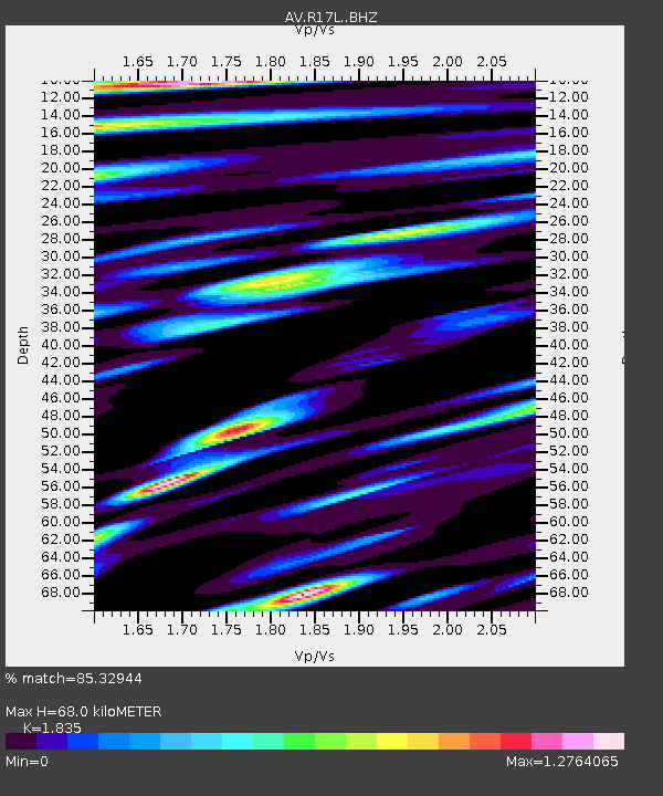
| Estimated Moho Depth: |
68.0 km |
| Estimated Crust Vp/Vs: |
1.84 |
| Assumed Crust Vp: |
6.1 km/s |
| Estimated Crust Vs: |
3.324 km/s |
| Estimated Crust Poisson's Ratio: |
0.29 |
|
| Radial Match: |
85.32944 % |
| Radial Bump: |
400 |
| Transverse Match: |
84.85762 % |
| Transverse Bump: |
400 |
| SOD ConfigId: |
25131211 |
| Insert Time: |
2021-08-09 12:16:12.910 +0000 |
| GWidth: |
2.5 |
| Max Bumps: |
400 |
| Tol: |
0.001 |
|

Signal To Noise
| Channel | StoN | STA | LTA |
| AV:R17L: :BHZ:20210726T12:21:16.349981Z | 16.045572 | 1.7691792E-6 | 1.1025965E-7 |
| AV:R17L: :BHN:20210726T12:21:16.349981Z | 4.3742533 | 4.226937E-7 | 9.663219E-8 |
| AV:R17L: :BHE:20210726T12:21:16.349981Z | 10.1272545 | 7.619099E-7 | 7.5233615E-8 |
| Arrivals |
| Ps | 9.5 SECOND |
| PpPs | 31 SECOND |
| PsPs/PpSs | 40 SECOND |


