You are here: Home > Network List > WI - West Indies IPGP Network Stations List
> Station MAGL Barre de l'ile, Marie-Galante, Guadeloupe > Earthquake Result Viewer
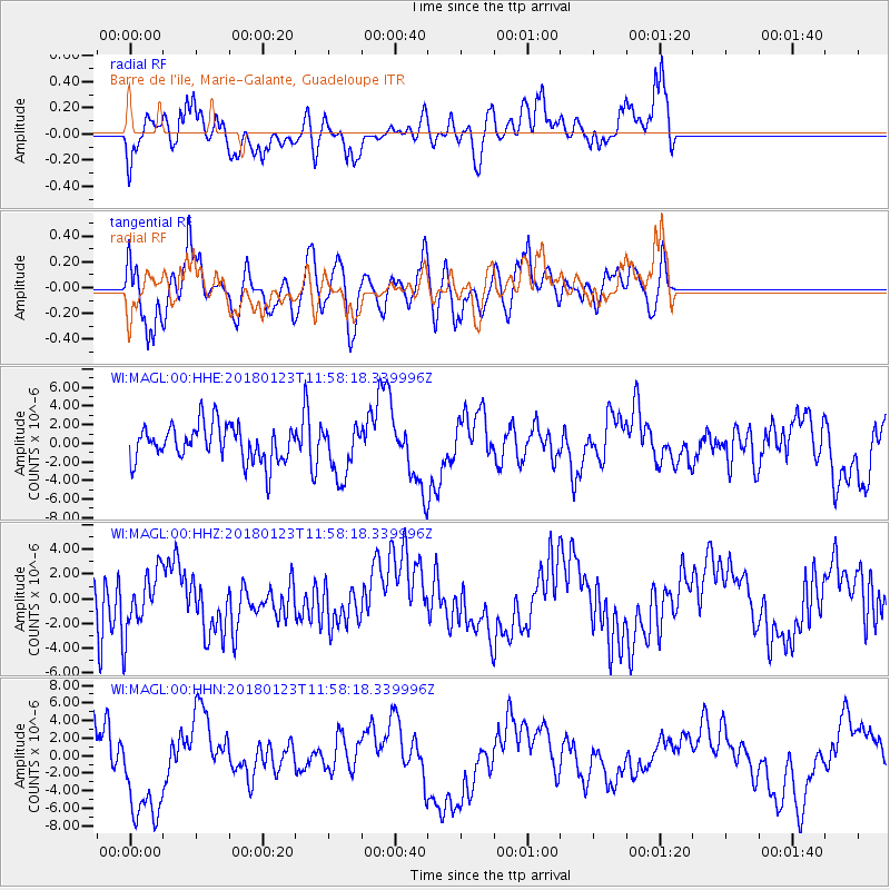
MAGL Barre de l'ile, Marie-Galante, Guadeloupe - Earthquake Result Viewer
*The percent match for this event was below the threshold and hence no stack was calculated.
| Earthquake location: |
Gulf Of Alaska |
| Earthquake latitude/longitude: |
56.6/-149.1 |
| Earthquake time(UTC): |
2018/01/23 (023) 11:47:03 GMT |
| Earthquake Depth: |
4.9 km |
| Earthquake Magnitude: |
5.6 mb |
| Earthquake Catalog/Contributor: |
NEIC PDE/ak |
|
| Network: |
WI West Indies IPGP Network |
| Station: |
MAGL Barre de l'ile, Marie-Galante, Guadeloupe |
| Lat/Lon: |
15.95 N/61.28 W |
| Elevation: |
159 m |
|
| Distance: |
75.7 deg |
| Az: |
82.811 deg |
| Baz: |
325.193 deg |
| Ray Param: |
$rayparam |
*The percent match for this event was below the threshold and hence was not used in the summary stack. |
|
| Radial Match: |
78.574005 % |
| Radial Bump: |
400 |
| Transverse Match: |
74.86991 % |
| Transverse Bump: |
400 |
| SOD ConfigId: |
2546091 |
| Insert Time: |
2018-02-06 11:50:58.157 +0000 |
| GWidth: |
2.5 |
| Max Bumps: |
400 |
| Tol: |
0.001 |
|
Signal To Noise
| Channel | StoN | STA | LTA |
| WI:MAGL:00:HHZ:20180123T11:58:18.339996Z | 1.0864639 | 2.3932175E-6 | 2.2027587E-6 |
| WI:MAGL:00:HHN:20180123T11:58:18.339996Z | 1.700622 | 6.3528296E-6 | 3.7355917E-6 |
| WI:MAGL:00:HHE:20180123T11:58:18.339996Z | 1.4184744 | 2.754869E-6 | 1.942135E-6 |
| Arrivals |
| Ps | |
| PpPs | |
| PsPs/PpSs | |


