You are here: Home > Network List > AV - Alaska Volcano Observatory Stations List
> Station TASO South, Tanaga Volcano, Alaska > Earthquake Result Viewer
TASO South, Tanaga Volcano, Alaska - Earthquake Result Viewer
| Earthquake location: |
Minahassa Peninsula, Sulawesi |
| Earthquake latitude/longitude: |
-0.7/121.9 |
| Earthquake time(UTC): |
2021/07/26 (207) 12:09:06 GMT |
| Earthquake Depth: |
11 km |
| Earthquake Magnitude: |
6.2 mww |
| Earthquake Catalog/Contributor: |
NEIC PDE/us |
|
| Network: |
AV Alaska Volcano Observatory |
| Station: |
TASO South, Tanaga Volcano, Alaska |
| Lat/Lon: |
51.85 N/178.15 W |
| Elevation: |
690 m |
|
| Distance: |
72.5 deg |
| Az: |
34.247 deg |
| Baz: |
245.129 deg |
| Ray Param: |
0.05362453 |
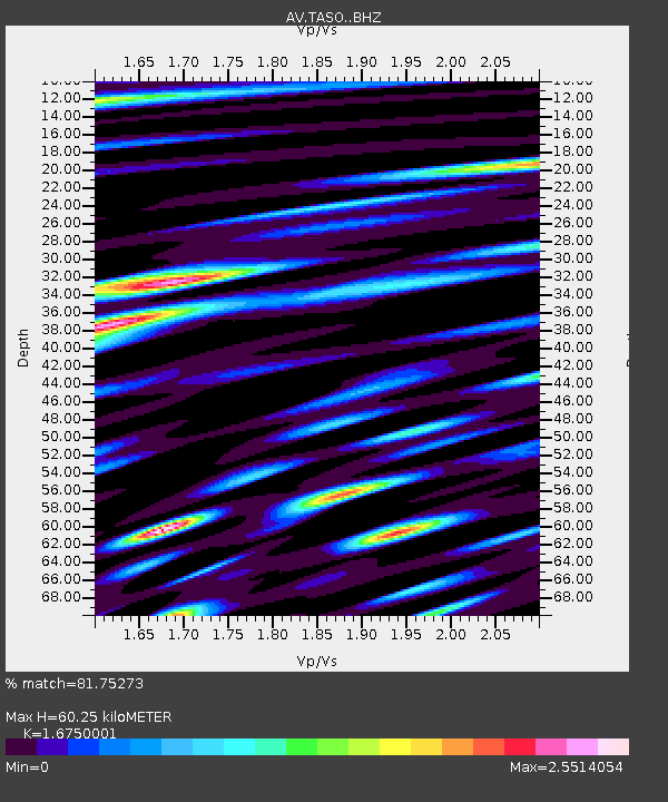
| Estimated Moho Depth: |
60.25 km |
| Estimated Crust Vp/Vs: |
1.68 |
| Assumed Crust Vp: |
6.048 km/s |
| Estimated Crust Vs: |
3.611 km/s |
| Estimated Crust Poisson's Ratio: |
0.22 |
|
| Radial Match: |
81.75273 % |
| Radial Bump: |
400 |
| Transverse Match: |
81.3941 % |
| Transverse Bump: |
400 |
| SOD ConfigId: |
25131211 |
| Insert Time: |
2021-08-09 12:16:35.378 +0000 |
| GWidth: |
2.5 |
| Max Bumps: |
400 |
| Tol: |
0.001 |
|

Signal To Noise
| Channel | StoN | STA | LTA |
| AV:TASO: :BHZ:20210726T12:20:02.039007Z | 6.863181 | 1.2591199E-6 | 1.8346012E-7 |
| AV:TASO: :BHN:20210726T12:20:02.039007Z | 1.49593 | 7.02784E-7 | 4.6979744E-7 |
| AV:TASO: :BHE:20210726T12:20:02.039007Z | 1.3851986 | 5.7703386E-7 | 4.1657117E-7 |
| Arrivals |
| Ps | 6.9 SECOND |
| PpPs | 26 SECOND |
| PsPs/PpSs | 33 SECOND |


