You are here: Home > Network List > CN - Canadian National Seismograph Network Stations List
> Station INK INUVIK, NT > Earthquake Result Viewer
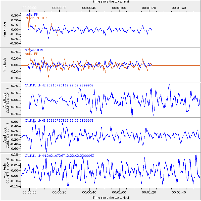
INK INUVIK, NT - Earthquake Result Viewer
*The percent match for this event was below the threshold and hence no stack was calculated.
| Earthquake location: |
Minahassa Peninsula, Sulawesi |
| Earthquake latitude/longitude: |
-0.7/121.9 |
| Earthquake time(UTC): |
2021/07/26 (207) 12:09:06 GMT |
| Earthquake Depth: |
11 km |
| Earthquake Magnitude: |
6.2 mww |
| Earthquake Catalog/Contributor: |
NEIC PDE/us |
|
| Network: |
CN Canadian National Seismograph Network |
| Station: |
INK INUVIK, NT |
| Lat/Lon: |
68.31 N/133.53 W |
| Elevation: |
44 m |
|
| Distance: |
96.0 deg |
| Az: |
21.216 deg |
| Baz: |
283.27 deg |
| Ray Param: |
$rayparam |
*The percent match for this event was below the threshold and hence was not used in the summary stack. |
|
| Radial Match: |
68.24925 % |
| Radial Bump: |
373 |
| Transverse Match: |
58.996464 % |
| Transverse Bump: |
400 |
| SOD ConfigId: |
25131211 |
| Insert Time: |
2021-08-09 12:17:07.962 +0000 |
| GWidth: |
2.5 |
| Max Bumps: |
400 |
| Tol: |
0.001 |
|
Signal To Noise
| Channel | StoN | STA | LTA |
| CN:INK: :HHZ:20210726T12:22:02.239996Z | 6.2581625 | 4.0395753E-7 | 6.45489E-8 |
| CN:INK: :HHN:20210726T12:22:02.239996Z | 0.8560904 | 3.4256832E-8 | 4.0015436E-8 |
| CN:INK: :HHE:20210726T12:22:02.239996Z | 2.0207322 | 9.995415E-8 | 4.9464326E-8 |
| Arrivals |
| Ps | |
| PpPs | |
| PsPs/PpSs | |


