You are here: Home > Network List > IU - Global Seismograph Network (GSN - IRIS/USGS) Stations List
> Station MAKZ Makanchi, Kazakhstan > Earthquake Result Viewer
MAKZ Makanchi, Kazakhstan - Earthquake Result Viewer
| Earthquake location: |
Minahassa Peninsula, Sulawesi |
| Earthquake latitude/longitude: |
-0.7/121.9 |
| Earthquake time(UTC): |
2021/07/26 (207) 12:09:06 GMT |
| Earthquake Depth: |
11 km |
| Earthquake Magnitude: |
6.2 mww |
| Earthquake Catalog/Contributor: |
NEIC PDE/us |
|
| Network: |
IU Global Seismograph Network (GSN - IRIS/USGS) |
| Station: |
MAKZ Makanchi, Kazakhstan |
| Lat/Lon: |
46.81 N/81.98 E |
| Elevation: |
600 m |
|
| Distance: |
58.9 deg |
| Az: |
328.98 deg |
| Baz: |
131.393 deg |
| Ray Param: |
0.06256498 |
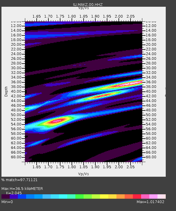
| Estimated Moho Depth: |
36.5 km |
| Estimated Crust Vp/Vs: |
2.05 |
| Assumed Crust Vp: |
6.571 km/s |
| Estimated Crust Vs: |
3.213 km/s |
| Estimated Crust Poisson's Ratio: |
0.34 |
|
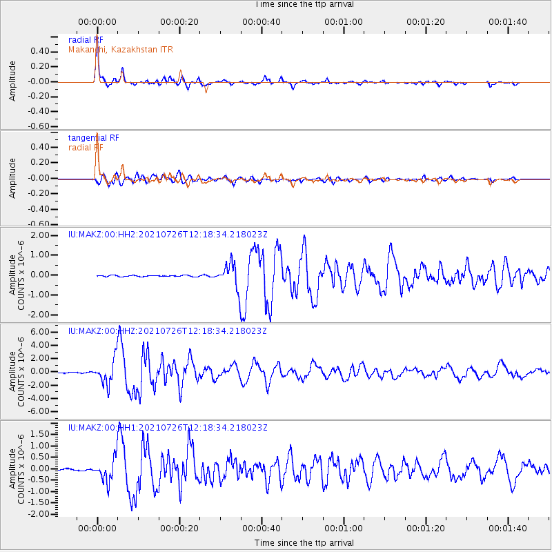
| Radial Match: |
97.71121 % |
| Radial Bump: |
316 |
| Transverse Match: |
90.25992 % |
| Transverse Bump: |
400 |
| SOD ConfigId: |
25131211 |
| Insert Time: |
2021-08-09 12:18:50.852 +0000 |
| GWidth: |
2.5 |
| Max Bumps: |
400 |
| Tol: |
0.001 |
|
Signal To Noise
| Channel | StoN | STA | LTA |
| IU:MAKZ:00:HHZ:20210726T12:18:34.218023Z | 38.987316 | 1.8892442E-6 | 4.8457917E-8 |
| IU:MAKZ:00:HH1:20210726T12:18:34.218023Z | 14.455821 | 5.098474E-7 | 3.526935E-8 |
| IU:MAKZ:00:HH2:20210726T12:18:34.218023Z | 22.22878 | 6.5168825E-7 | 2.931732E-8 |
| Arrivals |
| Ps | 6.1 SECOND |
| PpPs | 16 SECOND |
| PsPs/PpSs | 22 SECOND |


