You are here: Home > Network List > NK - Nepal Kathmandu (NK) Stations List
> Station KKN Kakani, Nepal > Earthquake Result Viewer
KKN Kakani, Nepal - Earthquake Result Viewer
| Earthquake location: |
Minahassa Peninsula, Sulawesi |
| Earthquake latitude/longitude: |
-0.7/121.9 |
| Earthquake time(UTC): |
2021/07/26 (207) 12:09:06 GMT |
| Earthquake Depth: |
11 km |
| Earthquake Magnitude: |
6.2 mww |
| Earthquake Catalog/Contributor: |
NEIC PDE/us |
|
| Network: |
NK Nepal Kathmandu (NK) |
| Station: |
KKN Kakani, Nepal |
| Lat/Lon: |
27.80 N/85.28 E |
| Elevation: |
2042 m |
|
| Distance: |
45.2 deg |
| Az: |
311.817 deg |
| Baz: |
122.731 deg |
| Ray Param: |
0.071440935 |
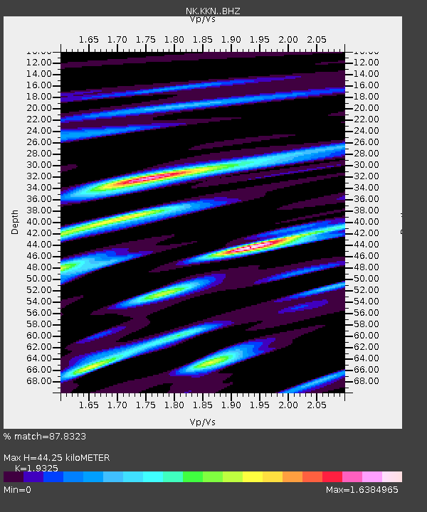
| Estimated Moho Depth: |
44.25 km |
| Estimated Crust Vp/Vs: |
1.93 |
| Assumed Crust Vp: |
6.142 km/s |
| Estimated Crust Vs: |
3.178 km/s |
| Estimated Crust Poisson's Ratio: |
0.32 |
|
| Radial Match: |
87.8323 % |
| Radial Bump: |
400 |
| Transverse Match: |
77.00614 % |
| Transverse Bump: |
400 |
| SOD ConfigId: |
25131211 |
| Insert Time: |
2021-08-09 12:19:55.149 +0000 |
| GWidth: |
2.5 |
| Max Bumps: |
400 |
| Tol: |
0.001 |
|

Signal To Noise
| Channel | StoN | STA | LTA |
| NK:KKN: :BHZ:20210726T12:16:52.660009Z | 11.372297 | 1.1833954E-6 | 1.0405948E-7 |
| NK:KKN: :BHN:20210726T12:16:52.660009Z | 2.0559227 | 4.4056927E-7 | 2.1429271E-7 |
| NK:KKN: :BHE:20210726T12:16:52.660009Z | 5.5893674 | 5.800342E-7 | 1.03774575E-7 |
| Arrivals |
| Ps | 7.1 SECOND |
| PpPs | 20 SECOND |
| PsPs/PpSs | 27 SECOND |


