You are here: Home > Network List > AK - Alaska Regional Network Stations List
> Station JIS Juneau Island, AK, USA > Earthquake Result Viewer
JIS Juneau Island, AK, USA - Earthquake Result Viewer
| Earthquake location: |
Near Coast Of Northern Peru |
| Earthquake latitude/longitude: |
-8.3/-80.0 |
| Earthquake time(UTC): |
2021/07/29 (210) 00:32:13 GMT |
| Earthquake Depth: |
23 km |
| Earthquake Magnitude: |
5.8 Mww |
| Earthquake Catalog/Contributor: |
NEIC PDE/us |
|
| Network: |
AK Alaska Regional Network |
| Station: |
JIS Juneau Island, AK, USA |
| Lat/Lon: |
58.28 N/134.38 W |
| Elevation: |
10 m |
|
| Distance: |
79.5 deg |
| Az: |
334.087 deg |
| Baz: |
125.071 deg |
| Ray Param: |
0.048885334 |
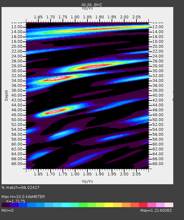
| Estimated Moho Depth: |
33.0 km |
| Estimated Crust Vp/Vs: |
1.72 |
| Assumed Crust Vp: |
6.566 km/s |
| Estimated Crust Vs: |
3.823 km/s |
| Estimated Crust Poisson's Ratio: |
0.24 |
|
| Radial Match: |
86.02427 % |
| Radial Bump: |
400 |
| Transverse Match: |
72.730705 % |
| Transverse Bump: |
400 |
| SOD ConfigId: |
25131211 |
| Insert Time: |
2021-08-12 00:34:35.424 +0000 |
| GWidth: |
2.5 |
| Max Bumps: |
400 |
| Tol: |
0.001 |
|

Signal To Noise
| Channel | StoN | STA | LTA |
| AK:JIS: :BHZ:20210729T00:43:47.42798Z | 7.787514 | 4.21241E-7 | 5.4091842E-8 |
| AK:JIS: :BHN:20210729T00:43:47.42798Z | 2.305724 | 1.242052E-7 | 5.3868202E-8 |
| AK:JIS: :BHE:20210729T00:43:47.42798Z | 2.7326417 | 1.4757234E-7 | 5.400354E-8 |
| Arrivals |
| Ps | 3.7 SECOND |
| PpPs | 13 SECOND |
| PsPs/PpSs | 17 SECOND |


