You are here: Home > Network List > G - GEOSCOPE Stations List
> Station NOUC Port Laguerre, New Caledonia > Earthquake Result Viewer
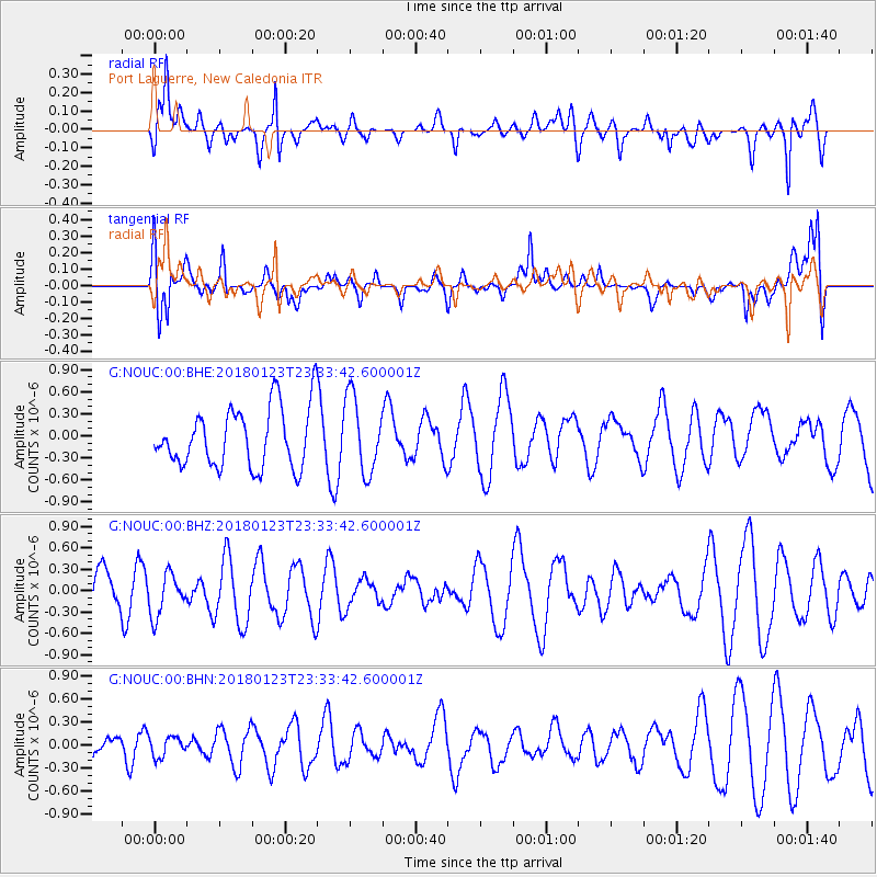
NOUC Port Laguerre, New Caledonia - Earthquake Result Viewer
*The percent match for this event was below the threshold and hence no stack was calculated.
| Earthquake location: |
Gulf Of Alaska |
| Earthquake latitude/longitude: |
56.6/-148.1 |
| Earthquake time(UTC): |
2018/01/23 (023) 23:21:27 GMT |
| Earthquake Depth: |
12 km |
| Earthquake Magnitude: |
5.3 Mww |
| Earthquake Catalog/Contributor: |
NEIC PDE/ak |
|
| Network: |
G GEOSCOPE |
| Station: |
NOUC Port Laguerre, New Caledonia |
| Lat/Lon: |
22.10 S/166.30 E |
| Elevation: |
112 m |
|
| Distance: |
87.3 deg |
| Az: |
221.517 deg |
| Baz: |
23.296 deg |
| Ray Param: |
$rayparam |
*The percent match for this event was below the threshold and hence was not used in the summary stack. |
|
| Radial Match: |
68.48462 % |
| Radial Bump: |
400 |
| Transverse Match: |
62.65313 % |
| Transverse Bump: |
400 |
| SOD ConfigId: |
2546091 |
| Insert Time: |
2018-02-06 23:22:11.050 +0000 |
| GWidth: |
2.5 |
| Max Bumps: |
400 |
| Tol: |
0.001 |
|
Signal To Noise
| Channel | StoN | STA | LTA |
| G:NOUC:00:BHZ:20180123T23:33:42.600001Z | 1.0780727 | 2.9823747E-7 | 2.7663947E-7 |
| G:NOUC:00:BHN:20180123T23:33:42.600001Z | 0.45100802 | 1.2812586E-7 | 2.8408775E-7 |
| G:NOUC:00:BHE:20180123T23:33:42.600001Z | 1.2678753 | 5.1567537E-7 | 4.0672407E-7 |
| Arrivals |
| Ps | |
| PpPs | |
| PsPs/PpSs | |


