You are here: Home > Network List > GS - US Geological Survey Networks Stations List
> Station OK051 E0350 and S34600 Roads, Ralston, OK > Earthquake Result Viewer
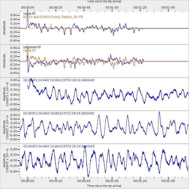
OK051 E0350 and S34600 Roads, Ralston, OK - Earthquake Result Viewer
*The percent match for this event was below the threshold and hence no stack was calculated.
| Earthquake location: |
Gulf Of Alaska |
| Earthquake latitude/longitude: |
56.6/-148.1 |
| Earthquake time(UTC): |
2018/01/23 (023) 23:21:27 GMT |
| Earthquake Depth: |
12 km |
| Earthquake Magnitude: |
5.3 Mww |
| Earthquake Catalog/Contributor: |
NEIC PDE/ak |
|
| Network: |
GS US Geological Survey Networks |
| Station: |
OK051 E0350 and S34600 Roads, Ralston, OK |
| Lat/Lon: |
36.51 N/96.84 W |
| Elevation: |
263 m |
|
| Distance: |
39.5 deg |
| Az: |
98.306 deg |
| Baz: |
317.19 deg |
| Ray Param: |
$rayparam |
*The percent match for this event was below the threshold and hence was not used in the summary stack. |
|
| Radial Match: |
50.700455 % |
| Radial Bump: |
346 |
| Transverse Match: |
42.728287 % |
| Transverse Bump: |
400 |
| SOD ConfigId: |
2546091 |
| Insert Time: |
2018-02-06 23:22:39.746 +0000 |
| GWidth: |
2.5 |
| Max Bumps: |
400 |
| Tol: |
0.001 |
|
Signal To Noise
| Channel | StoN | STA | LTA |
| GS:OK051:00:HHZ:20180123T23:28:26.980006Z | 1.1035868 | 2.219408E-7 | 2.011086E-7 |
| GS:OK051:00:HH1:20180123T23:28:26.980006Z | 1.3693557 | 2.2133239E-7 | 1.6163251E-7 |
| GS:OK051:00:HH2:20180123T23:28:26.980006Z | 1.5663425 | 4.9319476E-7 | 3.1487033E-7 |
| Arrivals |
| Ps | |
| PpPs | |
| PsPs/PpSs | |


