You are here: Home > Network List > C0 - Colorado Geological Survey Seismic Network Stations List
> Station T25A Trinidad, CO > Earthquake Result Viewer
T25A Trinidad, CO - Earthquake Result Viewer
| Earthquake location: |
Near Coast Of Northern Peru |
| Earthquake latitude/longitude: |
-8.3/-80.0 |
| Earthquake time(UTC): |
2021/07/29 (210) 00:32:13 GMT |
| Earthquake Depth: |
23 km |
| Earthquake Magnitude: |
5.8 Mww |
| Earthquake Catalog/Contributor: |
NEIC PDE/us |
|
| Network: |
C0 Colorado Geological Survey Seismic Network |
| Station: |
T25A Trinidad, CO |
| Lat/Lon: |
37.08 N/104.25 W |
| Elevation: |
1800 m |
|
| Distance: |
50.6 deg |
| Az: |
334.811 deg |
| Baz: |
148.221 deg |
| Ray Param: |
0.06792002 |
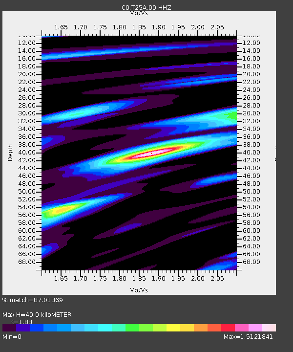
| Estimated Moho Depth: |
40.0 km |
| Estimated Crust Vp/Vs: |
1.88 |
| Assumed Crust Vp: |
6.316 km/s |
| Estimated Crust Vs: |
3.359 km/s |
| Estimated Crust Poisson's Ratio: |
0.30 |
|
| Radial Match: |
87.01369 % |
| Radial Bump: |
400 |
| Transverse Match: |
61.98042 % |
| Transverse Bump: |
398 |
| SOD ConfigId: |
25131211 |
| Insert Time: |
2021-08-12 00:38:36.218 +0000 |
| GWidth: |
2.5 |
| Max Bumps: |
400 |
| Tol: |
0.001 |
|

Signal To Noise
| Channel | StoN | STA | LTA |
| C0:T25A:00:HHZ:20210729T00:40:40.839998Z | 8.925765 | 4.044353E-7 | 4.5310998E-8 |
| C0:T25A:00:HHN:20210729T00:40:40.839998Z | 3.1193783 | 1.3649264E-7 | 4.3756362E-8 |
| C0:T25A:00:HHE:20210729T00:40:40.839998Z | 2.3170354 | 1.14811684E-7 | 4.955111E-8 |
| Arrivals |
| Ps | 5.9 SECOND |
| PpPs | 17 SECOND |
| PsPs/PpSs | 23 SECOND |


