You are here: Home > Network List > CI - Caltech Regional Seismic Network Stations List
> Station TIN Tinemaha, Big Pine, CA, USA > Earthquake Result Viewer
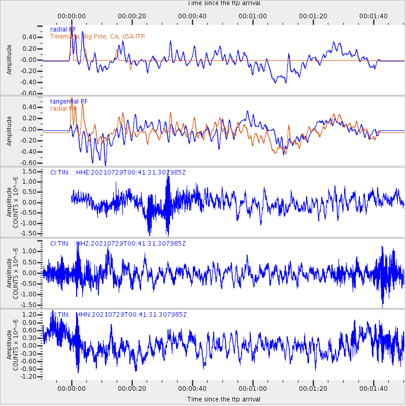
TIN Tinemaha, Big Pine, CA, USA - Earthquake Result Viewer
*The percent match for this event was below the threshold and hence no stack was calculated.
| Earthquake location: |
Near Coast Of Northern Peru |
| Earthquake latitude/longitude: |
-8.3/-80.0 |
| Earthquake time(UTC): |
2021/07/29 (210) 00:32:13 GMT |
| Earthquake Depth: |
23 km |
| Earthquake Magnitude: |
5.8 Mww |
| Earthquake Catalog/Contributor: |
NEIC PDE/us |
|
| Network: |
CI Caltech Regional Seismic Network |
| Station: |
TIN Tinemaha, Big Pine, CA, USA |
| Lat/Lon: |
37.05 N/118.23 W |
| Elevation: |
1197 m |
|
| Distance: |
57.6 deg |
| Az: |
324.093 deg |
| Baz: |
133.496 deg |
| Ray Param: |
$rayparam |
*The percent match for this event was below the threshold and hence was not used in the summary stack. |
|
| Radial Match: |
32.78962 % |
| Radial Bump: |
400 |
| Transverse Match: |
50.979393 % |
| Transverse Bump: |
400 |
| SOD ConfigId: |
25131211 |
| Insert Time: |
2021-08-12 00:41:45.053 +0000 |
| GWidth: |
2.5 |
| Max Bumps: |
400 |
| Tol: |
0.001 |
|
Signal To Noise
| Channel | StoN | STA | LTA |
| CI:TIN: :HHZ:20210729T00:41:31.307985Z | 1.7794636 | 4.2869922E-7 | 2.4091483E-7 |
| CI:TIN: :HHN:20210729T00:41:31.307985Z | 1.1008568 | 4.587136E-7 | 4.166878E-7 |
| CI:TIN: :HHE:20210729T00:41:31.307985Z | 2.0844157 | 6.04358E-7 | 2.899412E-7 |
| Arrivals |
| Ps | |
| PpPs | |
| PsPs/PpSs | |


