You are here: Home > Network List > NN - Western Great Basin/Eastern Sierra Nevada Stations List
> Station BEK Beckworth, CA, USA > Earthquake Result Viewer
BEK Beckworth, CA, USA - Earthquake Result Viewer
| Earthquake location: |
South Of Mariana Islands |
| Earthquake latitude/longitude: |
10.5/145.7 |
| Earthquake time(UTC): |
2007/09/30 (273) 02:08:30 GMT |
| Earthquake Depth: |
14 km |
| Earthquake Magnitude: |
6.4 MB, 7.1 MS, 6.9 MW, 6.9 MW |
| Earthquake Catalog/Contributor: |
WHDF/NEIC |
|
| Network: |
NN Western Great Basin/Eastern Sierra Nevada |
| Station: |
BEK Beckworth, CA, USA |
| Lat/Lon: |
39.87 N/120.36 W |
| Elevation: |
1743 m |
|
| Distance: |
86.4 deg |
| Az: |
50.299 deg |
| Baz: |
280.491 deg |
| Ray Param: |
0.044092882 |
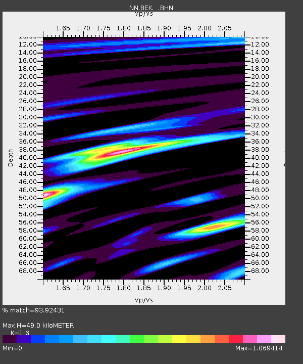
| Estimated Moho Depth: |
49.0 km |
| Estimated Crust Vp/Vs: |
1.60 |
| Assumed Crust Vp: |
6.597 km/s |
| Estimated Crust Vs: |
4.123 km/s |
| Estimated Crust Poisson's Ratio: |
0.18 |
|
| Radial Match: |
93.92431 % |
| Radial Bump: |
400 |
| Transverse Match: |
87.13948 % |
| Transverse Bump: |
400 |
| SOD ConfigId: |
2564 |
| Insert Time: |
2010-03-09 10:55:37.117 +0000 |
| GWidth: |
2.5 |
| Max Bumps: |
400 |
| Tol: |
0.001 |
|

Signal To Noise
| Channel | StoN | STA | LTA |
| NN:BEK: :BHN:20070930T02:20:40.295Z | 1.2401245 | 1.5102232E-7 | 1.2177996E-7 |
| NN:BEK: :BHE:20070930T02:20:40.295Z | 2.3664243 | 1.6979685E-7 | 7.1752496E-8 |
| NN:BEK: :BHZ:20070930T02:20:40.295Z | 4.56656 | 5.896869E-7 | 1.2913155E-7 |
| Arrivals |
| Ps | 4.6 SECOND |
| PpPs | 19 SECOND |
| PsPs/PpSs | 23 SECOND |


