You are here: Home > Network List > GS - US Geological Survey Networks Stations List
> Station ASA1 ASA1 > Earthquake Result Viewer
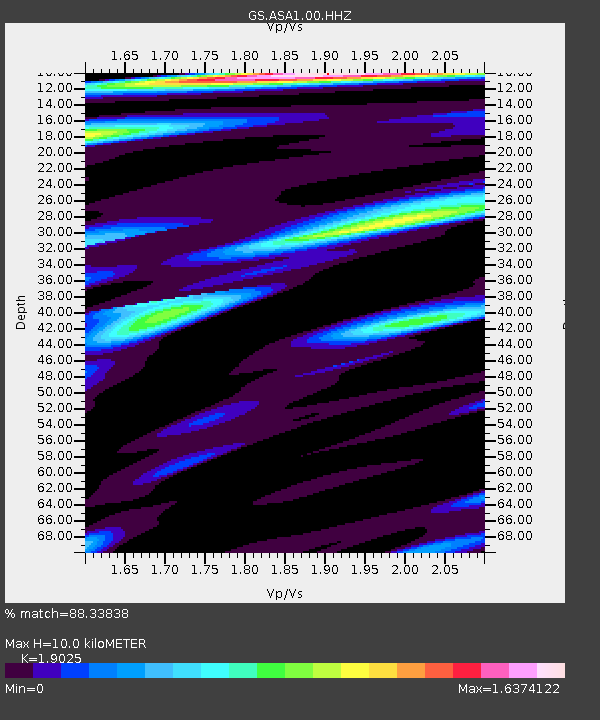
ASA1 ASA1 - Earthquake Result Viewer
| Earthquake location: |
Near Coast Of Northern Peru |
| Earthquake latitude/longitude: |
-8.3/-80.0 |
| Earthquake time(UTC): |
2021/07/29 (210) 00:32:13 GMT |
| Earthquake Depth: |
23 km |
| Earthquake Magnitude: |
5.8 Mww |
| Earthquake Catalog/Contributor: |
NEIC PDE/us |
|
| Network: |
GS US Geological Survey Networks |
| Station: |
ASA1 ASA1 |
| Lat/Lon: |
34.95 N/106.46 W |
| Elevation: |
1829 m |
|
| Distance: |
49.8 deg |
| Az: |
331.331 deg |
| Baz: |
144.696 deg |
| Ray Param: |
0.06844556 |
| Estimated Moho Depth: |
10.0 km |
| Estimated Crust Vp/Vs: |
1.90 |
| Assumed Crust Vp: |
6.502 km/s |
| Estimated Crust Vs: |
3.417 km/s |
| Estimated Crust Poisson's Ratio: |
0.31 |
|
| Radial Match: |
88.33838 % |
| Radial Bump: |
400 |
| Transverse Match: |
64.73867 % |
| Transverse Bump: |
400 |
| SOD ConfigId: |
25131211 |
| Insert Time: |
2021-08-12 00:46:14.267 +0000 |
| GWidth: |
2.5 |
| Max Bumps: |
400 |
| Tol: |
0.001 |
|

Signal To Noise
| Channel | StoN | STA | LTA |
| GS:ASA1:00:HHZ:20210729T00:40:34.019991Z | 3.8143375 | 2.6590436E-7 | 6.97118E-8 |
| GS:ASA1:00:HH1:20210729T00:40:34.019991Z | 2.8673503 | 1.441242E-7 | 5.0263893E-8 |
| GS:ASA1:00:HH2:20210729T00:40:34.019991Z | 2.7387638 | 1.09372884E-7 | 3.9935127E-8 |
| Arrivals |
| Ps | 1.5 SECOND |
| PpPs | 4.2 SECOND |
| PsPs/PpSs | 5.7 SECOND |


