You are here: Home > Network List > GS - US Geological Survey Networks Stations List
> Station DEC08 Union Local 159 Surface Site > Earthquake Result Viewer
DEC08 Union Local 159 Surface Site - Earthquake Result Viewer
| Earthquake location: |
Near Coast Of Northern Peru |
| Earthquake latitude/longitude: |
-8.3/-80.0 |
| Earthquake time(UTC): |
2021/07/29 (210) 00:32:13 GMT |
| Earthquake Depth: |
23 km |
| Earthquake Magnitude: |
5.8 Mww |
| Earthquake Catalog/Contributor: |
NEIC PDE/us |
|
| Network: |
GS US Geological Survey Networks |
| Station: |
DEC08 Union Local 159 Surface Site |
| Lat/Lon: |
39.86 N/88.92 W |
| Elevation: |
210 m |
|
| Distance: |
48.7 deg |
| Az: |
350.816 deg |
| Baz: |
168.159 deg |
| Ray Param: |
0.069179505 |
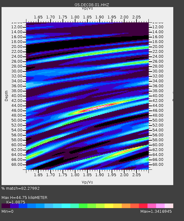
| Estimated Moho Depth: |
44.75 km |
| Estimated Crust Vp/Vs: |
1.89 |
| Assumed Crust Vp: |
6.444 km/s |
| Estimated Crust Vs: |
3.414 km/s |
| Estimated Crust Poisson's Ratio: |
0.30 |
|
| Radial Match: |
82.27992 % |
| Radial Bump: |
400 |
| Transverse Match: |
56.52031 % |
| Transverse Bump: |
400 |
| SOD ConfigId: |
25131211 |
| Insert Time: |
2021-08-12 00:46:27.788 +0000 |
| GWidth: |
2.5 |
| Max Bumps: |
400 |
| Tol: |
0.001 |
|
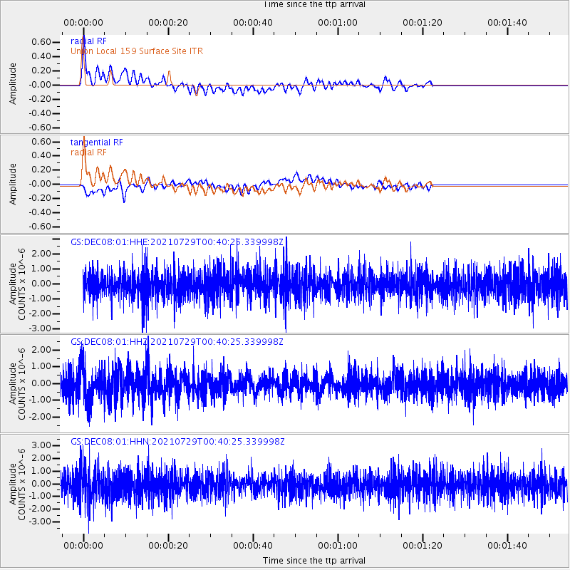
Signal To Noise
| Channel | StoN | STA | LTA |
| GS:DEC08:01:HHZ:20210729T00:40:25.339998Z | 1.7184744 | 1.0849644E-6 | 6.3135326E-7 |
| GS:DEC08:01:HHN:20210729T00:40:25.339998Z | 1.3567804 | 1.3402641E-6 | 9.878268E-7 |
| GS:DEC08:01:HHE:20210729T00:40:25.339998Z | 1.1493807 | 1.0123496E-6 | 8.8077826E-7 |
| Arrivals |
| Ps | 6.5 SECOND |
| PpPs | 19 SECOND |
| PsPs/PpSs | 25 SECOND |


