You are here: Home > Network List > NN - Western Great Basin/Eastern Sierra Nevada Stations List
> Station BEK Beckworth, CA, USA > Earthquake Result Viewer
BEK Beckworth, CA, USA - Earthquake Result Viewer
| Earthquake location: |
Kuril Islands |
| Earthquake latitude/longitude: |
46.0/151.4 |
| Earthquake time(UTC): |
2009/04/18 (108) 19:17:58 GMT |
| Earthquake Depth: |
35 km |
| Earthquake Magnitude: |
6.3 MB, 6.3 MS, 6.6 MW, 6.4 MW |
| Earthquake Catalog/Contributor: |
WHDF/NEIC |
|
| Network: |
NN Western Great Basin/Eastern Sierra Nevada |
| Station: |
BEK Beckworth, CA, USA |
| Lat/Lon: |
39.87 N/120.36 W |
| Elevation: |
1743 m |
|
| Distance: |
61.7 deg |
| Az: |
60.925 deg |
| Baz: |
307.688 deg |
| Ray Param: |
0.06067012 |
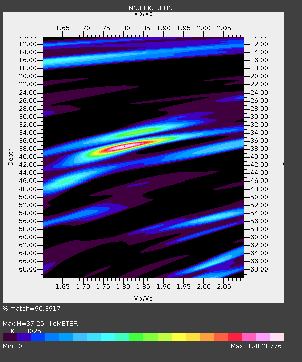
| Estimated Moho Depth: |
37.25 km |
| Estimated Crust Vp/Vs: |
1.80 |
| Assumed Crust Vp: |
6.597 km/s |
| Estimated Crust Vs: |
3.66 km/s |
| Estimated Crust Poisson's Ratio: |
0.28 |
|
| Radial Match: |
90.3917 % |
| Radial Bump: |
400 |
| Transverse Match: |
64.285225 % |
| Transverse Bump: |
400 |
| SOD ConfigId: |
2658 |
| Insert Time: |
2010-03-09 10:56:15.993 +0000 |
| GWidth: |
2.5 |
| Max Bumps: |
400 |
| Tol: |
0.001 |
|

Signal To Noise
| Channel | StoN | STA | LTA |
| NN:BEK: :BHN:20090418T19:27:42.594001Z | 17.073572 | 6.0801466E-7 | 3.561145E-8 |
| NN:BEK: :BHE:20090418T19:27:42.594001Z | 1.4853314 | 1.7660965E-7 | 1.1890252E-7 |
| NN:BEK: :BHZ:20090418T19:27:42.594001Z | 3.1734765 | 5.246113E-7 | 1.6531123E-7 |
| Arrivals |
| Ps | 4.7 SECOND |
| PpPs | 15 SECOND |
| PsPs/PpSs | 20 SECOND |


