You are here: Home > Network List > LD - Lamont-Doherty Cooperative Seismographic Network Stations List
> Station FMMC Franklin & Marshall College/Millport Conservancy, PA > Earthquake Result Viewer
FMMC Franklin & Marshall College/Millport Conservancy, PA - Earthquake Result Viewer

| Earthquake location: |
Near Coast Of Northern Peru |
| Earthquake latitude/longitude: |
-8.3/-80.0 |
| Earthquake time(UTC): |
2021/07/29 (210) 00:32:13 GMT |
| Earthquake Depth: |
23 km |
| Earthquake Magnitude: |
5.8 Mww |
| Earthquake Catalog/Contributor: |
NEIC PDE/us |
|
| Network: |
LD Lamont-Doherty Cooperative Seismographic Network |
| Station: |
FMMC Franklin & Marshall College/Millport Conservancy, PA |
| Lat/Lon: |
40.14 N/76.26 W |
| Elevation: |
101 m |
|
| Distance: |
48.4 deg |
| Az: |
3.804 deg |
| Baz: |
184.913 deg |
| Ray Param: |
0.06938254 |
| Estimated Moho Depth: |
49.75 km |
| Estimated Crust Vp/Vs: |
1.60 |
| Assumed Crust Vp: |
6.121 km/s |
| Estimated Crust Vs: |
3.825 km/s |
| Estimated Crust Poisson's Ratio: |
0.18 |
|
| Radial Match: |
85.21222 % |
| Radial Bump: |
400 |
| Transverse Match: |
73.785034 % |
| Transverse Bump: |
400 |
| SOD ConfigId: |
25131211 |
| Insert Time: |
2021-08-12 00:47:50.743 +0000 |
| GWidth: |
2.5 |
| Max Bumps: |
400 |
| Tol: |
0.001 |
|
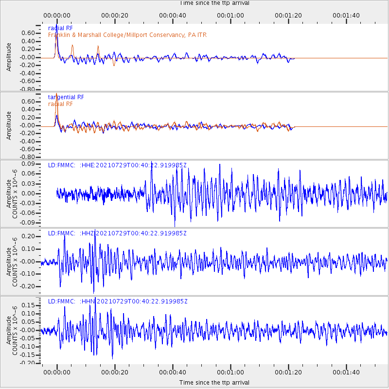
Signal To Noise
| Channel | StoN | STA | LTA |
| LD:FMMC: :HHZ:20210729T00:40:22.919985Z | 7.559958 | 8.4755705E-8 | 1.1211134E-8 |
| LD:FMMC: :HHN:20210729T00:40:22.919985Z | 5.3552766 | 5.510501E-8 | 1.0289853E-8 |
| LD:FMMC: :HHE:20210729T00:40:22.919985Z | 2.9375184 | 3.1593203E-8 | 1.0755065E-8 |
| Arrivals |
| Ps | 5.2 SECOND |
| PpPs | 20 SECOND |
| PsPs/PpSs | 25 SECOND |


