You are here: Home > Network List > N4 - Central and EAstern US Network Stations List
> Station E62A Clayton Lake, ME, USA > Earthquake Result Viewer
E62A Clayton Lake, ME, USA - Earthquake Result Viewer
| Earthquake location: |
Near Coast Of Northern Peru |
| Earthquake latitude/longitude: |
-8.3/-80.0 |
| Earthquake time(UTC): |
2021/07/29 (210) 00:32:13 GMT |
| Earthquake Depth: |
23 km |
| Earthquake Magnitude: |
5.8 Mww |
| Earthquake Catalog/Contributor: |
NEIC PDE/us |
|
| Network: |
N4 Central and EAstern US Network |
| Station: |
E62A Clayton Lake, ME, USA |
| Lat/Lon: |
46.62 N/69.52 W |
| Elevation: |
356 m |
|
| Distance: |
55.5 deg |
| Az: |
8.72 deg |
| Baz: |
192.572 deg |
| Ray Param: |
0.0647155 |
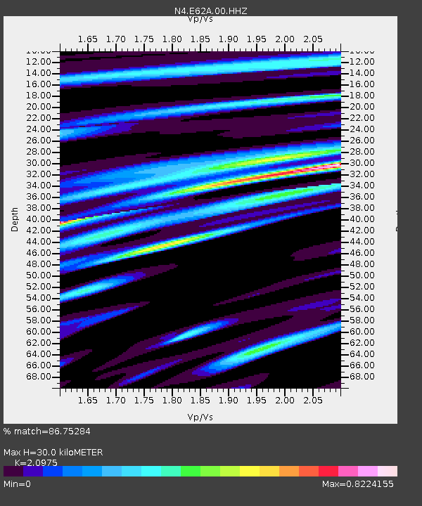
| Estimated Moho Depth: |
30.0 km |
| Estimated Crust Vp/Vs: |
2.10 |
| Assumed Crust Vp: |
6.419 km/s |
| Estimated Crust Vs: |
3.06 km/s |
| Estimated Crust Poisson's Ratio: |
0.35 |
|
| Radial Match: |
86.75284 % |
| Radial Bump: |
400 |
| Transverse Match: |
75.54891 % |
| Transverse Bump: |
400 |
| SOD ConfigId: |
25131211 |
| Insert Time: |
2021-08-12 00:49:02.651 +0000 |
| GWidth: |
2.5 |
| Max Bumps: |
400 |
| Tol: |
0.001 |
|

Signal To Noise
| Channel | StoN | STA | LTA |
| N4:E62A:00:HHZ:20210729T00:41:16.078981Z | 10.783673 | 9.3273377E-7 | 8.649499E-8 |
| N4:E62A:00:HH1:20210729T00:41:16.078981Z | 7.5199575 | 5.478142E-7 | 7.2848046E-8 |
| N4:E62A:00:HH2:20210729T00:41:16.078981Z | 1.7088563 | 1.2258205E-7 | 7.173338E-8 |
| Arrivals |
| Ps | 5.4 SECOND |
| PpPs | 14 SECOND |
| PsPs/PpSs | 19 SECOND |


