You are here: Home > Network List > IU - Global Seismograph Network (GSN - IRIS/USGS) Stations List
> Station PMG Port Moresby, New Guinea > Earthquake Result Viewer
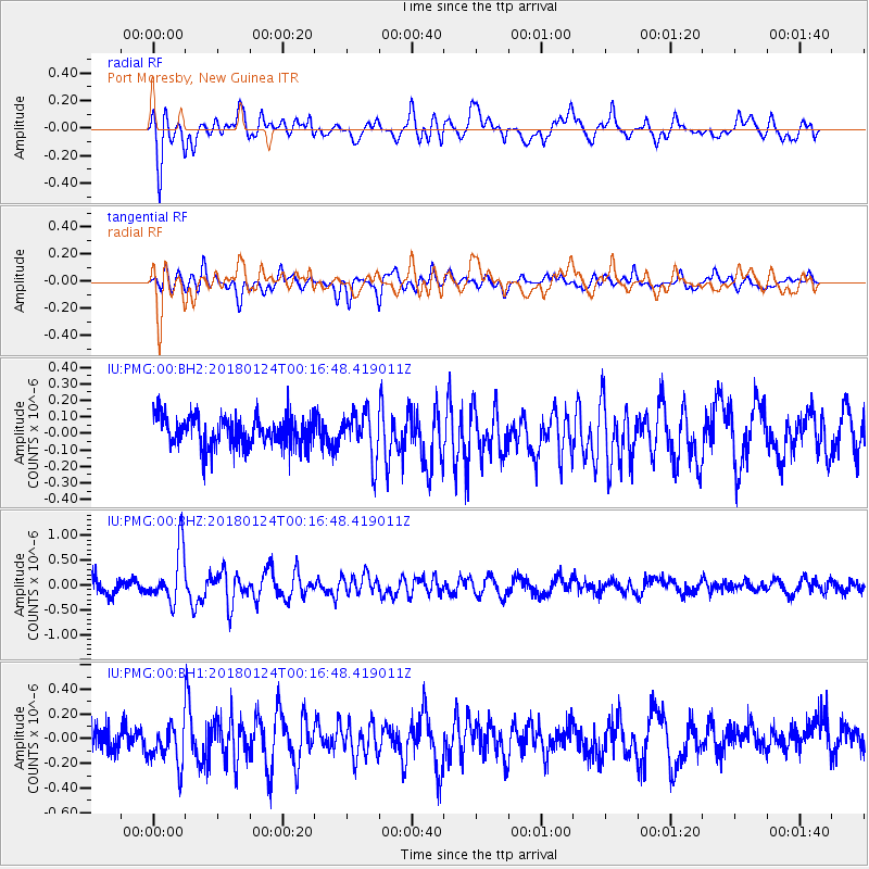
PMG Port Moresby, New Guinea - Earthquake Result Viewer
*The percent match for this event was below the threshold and hence no stack was calculated.
| Earthquake location: |
Gulf Of Alaska |
| Earthquake latitude/longitude: |
56.5/-148.5 |
| Earthquake time(UTC): |
2018/01/24 (024) 00:04:48 GMT |
| Earthquake Depth: |
10 km |
| Earthquake Magnitude: |
5.5 Mww |
| Earthquake Catalog/Contributor: |
NEIC PDE/us |
|
| Network: |
IU Global Seismograph Network (GSN - IRIS/USGS) |
| Station: |
PMG Port Moresby, New Guinea |
| Lat/Lon: |
9.40 S/147.16 E |
| Elevation: |
90 m |
|
| Distance: |
84.2 deg |
| Az: |
243.374 deg |
| Baz: |
30.128 deg |
| Ray Param: |
$rayparam |
*The percent match for this event was below the threshold and hence was not used in the summary stack. |
|
| Radial Match: |
74.68604 % |
| Radial Bump: |
400 |
| Transverse Match: |
65.154625 % |
| Transverse Bump: |
400 |
| SOD ConfigId: |
2546091 |
| Insert Time: |
2018-02-07 00:08:17.986 +0000 |
| GWidth: |
2.5 |
| Max Bumps: |
400 |
| Tol: |
0.001 |
|
Signal To Noise
| Channel | StoN | STA | LTA |
| IU:PMG:00:BHZ:20180124T00:16:48.419011Z | 4.4724684 | 5.334173E-7 | 1.1926687E-7 |
| IU:PMG:00:BH1:20180124T00:16:48.419011Z | 1.8627486 | 1.690556E-7 | 9.075599E-8 |
| IU:PMG:00:BH2:20180124T00:16:48.419011Z | 1.5475572 | 1.4010686E-7 | 9.05342E-8 |
| Arrivals |
| Ps | |
| PpPs | |
| PsPs/PpSs | |


