You are here: Home > Network List > N4 - Central and EAstern US Network Stations List
> Station S57A Dark Hallow, Roseland, VA, USA > Earthquake Result Viewer
S57A Dark Hallow, Roseland, VA, USA - Earthquake Result Viewer
| Earthquake location: |
Near Coast Of Northern Peru |
| Earthquake latitude/longitude: |
-8.3/-80.0 |
| Earthquake time(UTC): |
2021/07/29 (210) 00:32:13 GMT |
| Earthquake Depth: |
23 km |
| Earthquake Magnitude: |
5.8 Mww |
| Earthquake Catalog/Contributor: |
NEIC PDE/us |
|
| Network: |
N4 Central and EAstern US Network |
| Station: |
S57A Dark Hallow, Roseland, VA, USA |
| Lat/Lon: |
37.76 N/78.95 W |
| Elevation: |
264 m |
|
| Distance: |
45.9 deg |
| Az: |
1.119 deg |
| Baz: |
181.397 deg |
| Ray Param: |
0.070978776 |
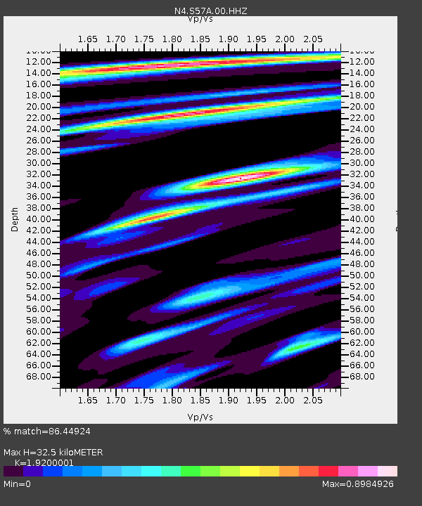
| Estimated Moho Depth: |
32.5 km |
| Estimated Crust Vp/Vs: |
1.92 |
| Assumed Crust Vp: |
6.419 km/s |
| Estimated Crust Vs: |
3.343 km/s |
| Estimated Crust Poisson's Ratio: |
0.31 |
|
| Radial Match: |
86.44924 % |
| Radial Bump: |
373 |
| Transverse Match: |
63.18831 % |
| Transverse Bump: |
400 |
| SOD ConfigId: |
25131211 |
| Insert Time: |
2021-08-12 00:50:31.690 +0000 |
| GWidth: |
2.5 |
| Max Bumps: |
400 |
| Tol: |
0.001 |
|

Signal To Noise
| Channel | StoN | STA | LTA |
| N4:S57A:00:HHZ:20210729T00:40:03.569002Z | 7.1865187 | 4.992598E-7 | 6.947171E-8 |
| N4:S57A:00:HH1:20210729T00:40:03.569002Z | 7.4565783 | 3.3654956E-7 | 4.5134584E-8 |
| N4:S57A:00:HH2:20210729T00:40:03.569002Z | 1.3876776 | 6.726326E-8 | 4.8471822E-8 |
| Arrivals |
| Ps | 4.9 SECOND |
| PpPs | 14 SECOND |
| PsPs/PpSs | 19 SECOND |


