You are here: Home > Network List > O2 - Oklahoma Consolidated Temporary Seismic Networks Stations List
> Station FW04 Hopeton, Oklahoma, USA > Earthquake Result Viewer
FW04 Hopeton, Oklahoma, USA - Earthquake Result Viewer
| Earthquake location: |
Near Coast Of Northern Peru |
| Earthquake latitude/longitude: |
-8.3/-80.0 |
| Earthquake time(UTC): |
2021/07/29 (210) 00:32:13 GMT |
| Earthquake Depth: |
23 km |
| Earthquake Magnitude: |
5.8 Mww |
| Earthquake Catalog/Contributor: |
NEIC PDE/us |
|
| Network: |
O2 Oklahoma Consolidated Temporary Seismic Networks |
| Station: |
FW04 Hopeton, Oklahoma, USA |
| Lat/Lon: |
36.60 N/98.67 W |
| Elevation: |
448 m |
|
| Distance: |
48.0 deg |
| Az: |
339.694 deg |
| Baz: |
154.74 deg |
| Ray Param: |
0.06960112 |
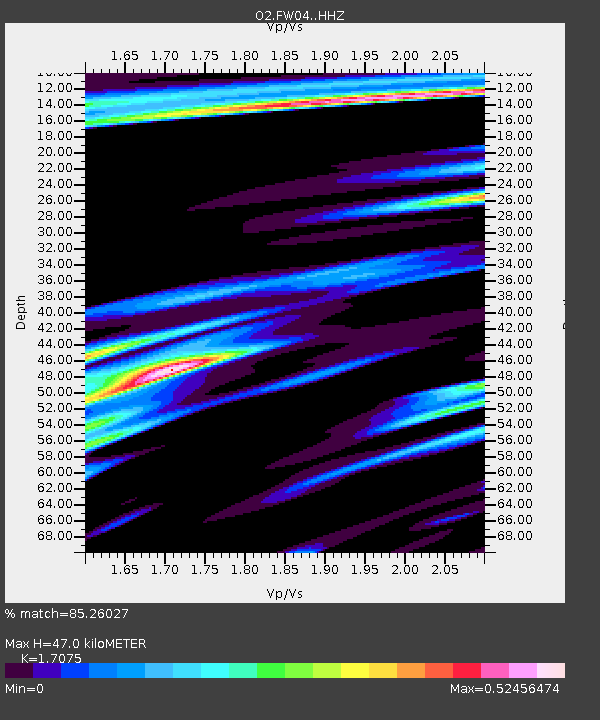
| Estimated Moho Depth: |
47.0 km |
| Estimated Crust Vp/Vs: |
1.71 |
| Assumed Crust Vp: |
6.426 km/s |
| Estimated Crust Vs: |
3.763 km/s |
| Estimated Crust Poisson's Ratio: |
0.24 |
|
| Radial Match: |
85.26027 % |
| Radial Bump: |
338 |
| Transverse Match: |
65.17168 % |
| Transverse Bump: |
400 |
| SOD ConfigId: |
25131211 |
| Insert Time: |
2021-08-12 00:52:58.476 +0000 |
| GWidth: |
2.5 |
| Max Bumps: |
400 |
| Tol: |
0.001 |
|

Signal To Noise
| Channel | StoN | STA | LTA |
| O2:FW04: :HHZ:20210729T00:40:20.385012Z | 7.271807 | 5.895882E-7 | 8.107863E-8 |
| O2:FW04: :HHN:20210729T00:40:20.385012Z | 3.6194704 | 3.0849648E-7 | 8.523249E-8 |
| O2:FW04: :HHE:20210729T00:40:20.385012Z | 2.752787 | 2.3056928E-7 | 8.375848E-8 |
| Arrivals |
| Ps | 5.5 SECOND |
| PpPs | 19 SECOND |
| PsPs/PpSs | 24 SECOND |


