You are here: Home > Network List > O2 - Oklahoma Consolidated Temporary Seismic Networks Stations List
> Station PW10 Pawnee, Oklahoma > Earthquake Result Viewer
PW10 Pawnee, Oklahoma - Earthquake Result Viewer
| Earthquake location: |
Near Coast Of Northern Peru |
| Earthquake latitude/longitude: |
-8.3/-80.0 |
| Earthquake time(UTC): |
2021/07/29 (210) 00:32:13 GMT |
| Earthquake Depth: |
23 km |
| Earthquake Magnitude: |
5.8 Mww |
| Earthquake Catalog/Contributor: |
NEIC PDE/us |
|
| Network: |
O2 Oklahoma Consolidated Temporary Seismic Networks |
| Station: |
PW10 Pawnee, Oklahoma |
| Lat/Lon: |
36.37 N/96.83 W |
| Elevation: |
297 m |
|
| Distance: |
47.2 deg |
| Az: |
341.393 deg |
| Baz: |
156.971 deg |
| Ray Param: |
0.07011113 |
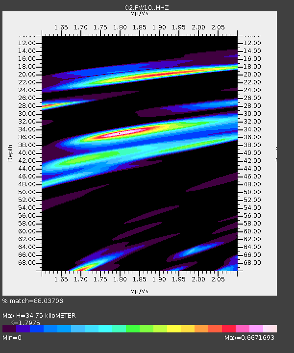
| Estimated Moho Depth: |
34.75 km |
| Estimated Crust Vp/Vs: |
1.80 |
| Assumed Crust Vp: |
6.483 km/s |
| Estimated Crust Vs: |
3.606 km/s |
| Estimated Crust Poisson's Ratio: |
0.28 |
|
| Radial Match: |
88.03706 % |
| Radial Bump: |
342 |
| Transverse Match: |
75.54735 % |
| Transverse Bump: |
400 |
| SOD ConfigId: |
25131211 |
| Insert Time: |
2021-08-12 00:53:18.954 +0000 |
| GWidth: |
2.5 |
| Max Bumps: |
400 |
| Tol: |
0.001 |
|

Signal To Noise
| Channel | StoN | STA | LTA |
| O2:PW10: :HHZ:20210729T00:40:14.070009Z | 13.658278 | 6.5106804E-7 | 4.7668383E-8 |
| O2:PW10: :HHN:20210729T00:40:14.070009Z | 7.0832686 | 3.494032E-7 | 4.9327962E-8 |
| O2:PW10: :HHE:20210729T00:40:14.070009Z | 5.1700478 | 3.3057327E-7 | 6.394008E-8 |
| Arrivals |
| Ps | 4.5 SECOND |
| PpPs | 14 SECOND |
| PsPs/PpSs | 19 SECOND |


