You are here: Home > Network List > TA - USArray Transportable Network (new EarthScope stations) Stations List
> Station A36M Sachs Harbour, NT, CAN > Earthquake Result Viewer
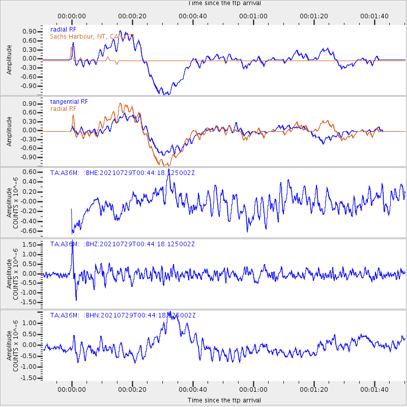
A36M Sachs Harbour, NT, CAN - Earthquake Result Viewer
*The percent match for this event was below the threshold and hence no stack was calculated.
| Earthquake location: |
Near Coast Of Northern Peru |
| Earthquake latitude/longitude: |
-8.3/-80.0 |
| Earthquake time(UTC): |
2021/07/29 (210) 00:32:13 GMT |
| Earthquake Depth: |
23 km |
| Earthquake Magnitude: |
5.8 Mww |
| Earthquake Catalog/Contributor: |
NEIC PDE/us |
|
| Network: |
TA USArray Transportable Network (new EarthScope stations) |
| Station: |
A36M Sachs Harbour, NT, CAN |
| Lat/Lon: |
71.99 N/125.25 W |
| Elevation: |
32 m |
|
| Distance: |
85.4 deg |
| Az: |
347.187 deg |
| Baz: |
135.139 deg |
| Ray Param: |
$rayparam |
*The percent match for this event was below the threshold and hence was not used in the summary stack. |
|
| Radial Match: |
39.183643 % |
| Radial Bump: |
400 |
| Transverse Match: |
48.19944 % |
| Transverse Bump: |
400 |
| SOD ConfigId: |
25131211 |
| Insert Time: |
2021-08-12 00:56:59.651 +0000 |
| GWidth: |
2.5 |
| Max Bumps: |
400 |
| Tol: |
0.001 |
|
Signal To Noise
| Channel | StoN | STA | LTA |
| TA:A36M: :BHZ:20210729T00:44:18.125002Z | 7.3584566 | 6.0366045E-7 | 8.203629E-8 |
| TA:A36M: :BHN:20210729T00:44:18.125002Z | 2.4620547 | 4.1073088E-7 | 1.6682444E-7 |
| TA:A36M: :BHE:20210729T00:44:18.125002Z | 2.2461963 | 4.4231444E-7 | 1.9691709E-7 |
| Arrivals |
| Ps | |
| PpPs | |
| PsPs/PpSs | |


