You are here: Home > Network List > TX - Texas Seismological Network Stations List
> Station RTBA Rita Blanca > Earthquake Result Viewer
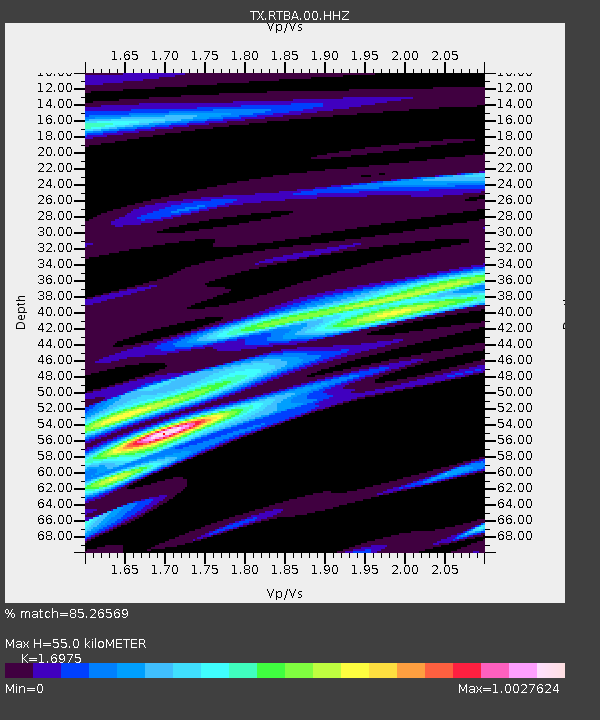
RTBA Rita Blanca - Earthquake Result Viewer
| Earthquake location: |
Near Coast Of Northern Peru |
| Earthquake latitude/longitude: |
-8.3/-80.0 |
| Earthquake time(UTC): |
2021/07/29 (210) 00:32:13 GMT |
| Earthquake Depth: |
23 km |
| Earthquake Magnitude: |
5.8 Mww |
| Earthquake Catalog/Contributor: |
NEIC PDE/us |
|
| Network: |
TX Texas Seismological Network |
| Station: |
RTBA Rita Blanca |
| Lat/Lon: |
36.44 N/102.74 W |
| Elevation: |
1284 m |
|
| Distance: |
49.4 deg |
| Az: |
335.734 deg |
| Baz: |
149.713 deg |
| Ray Param: |
0.068699345 |
| Estimated Moho Depth: |
55.0 km |
| Estimated Crust Vp/Vs: |
1.70 |
| Assumed Crust Vp: |
6.306 km/s |
| Estimated Crust Vs: |
3.715 km/s |
| Estimated Crust Poisson's Ratio: |
0.23 |
|
| Radial Match: |
85.26569 % |
| Radial Bump: |
307 |
| Transverse Match: |
63.707764 % |
| Transverse Bump: |
397 |
| SOD ConfigId: |
25131211 |
| Insert Time: |
2021-08-12 00:58:24.507 +0000 |
| GWidth: |
2.5 |
| Max Bumps: |
400 |
| Tol: |
0.001 |
|

Signal To Noise
| Channel | StoN | STA | LTA |
| TX:RTBA:00:HHZ:20210729T00:40:31.04001Z | 12.074442 | 6.144473E-7 | 5.0888254E-8 |
| TX:RTBA:00:HH1:20210729T00:40:31.04001Z | 2.4255824 | 2.0186728E-7 | 8.322425E-8 |
| TX:RTBA:00:HH2:20210729T00:40:31.04001Z | 4.2397566 | 2.5773045E-7 | 6.078897E-8 |
| Arrivals |
| Ps | 6.5 SECOND |
| PpPs | 22 SECOND |
| PsPs/PpSs | 29 SECOND |


