You are here: Home > Network List > US - United States National Seismic Network Stations List
> Station BRAL Brewton, Alabama, USA > Earthquake Result Viewer
BRAL Brewton, Alabama, USA - Earthquake Result Viewer
| Earthquake location: |
Near Coast Of Northern Peru |
| Earthquake latitude/longitude: |
-8.3/-80.0 |
| Earthquake time(UTC): |
2021/07/29 (210) 00:32:13 GMT |
| Earthquake Depth: |
23 km |
| Earthquake Magnitude: |
5.8 Mww |
| Earthquake Catalog/Contributor: |
NEIC PDE/us |
|
| Network: |
US United States National Seismic Network |
| Station: |
BRAL Brewton, Alabama, USA |
| Lat/Lon: |
31.17 N/87.05 W |
| Elevation: |
61 m |
|
| Distance: |
39.9 deg |
| Az: |
350.508 deg |
| Baz: |
169.025 deg |
| Ray Param: |
0.07469763 |
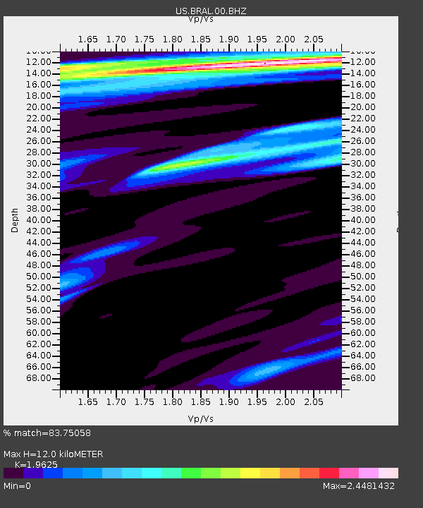
| Estimated Moho Depth: |
12.0 km |
| Estimated Crust Vp/Vs: |
1.96 |
| Assumed Crust Vp: |
6.187 km/s |
| Estimated Crust Vs: |
3.152 km/s |
| Estimated Crust Poisson's Ratio: |
0.32 |
|
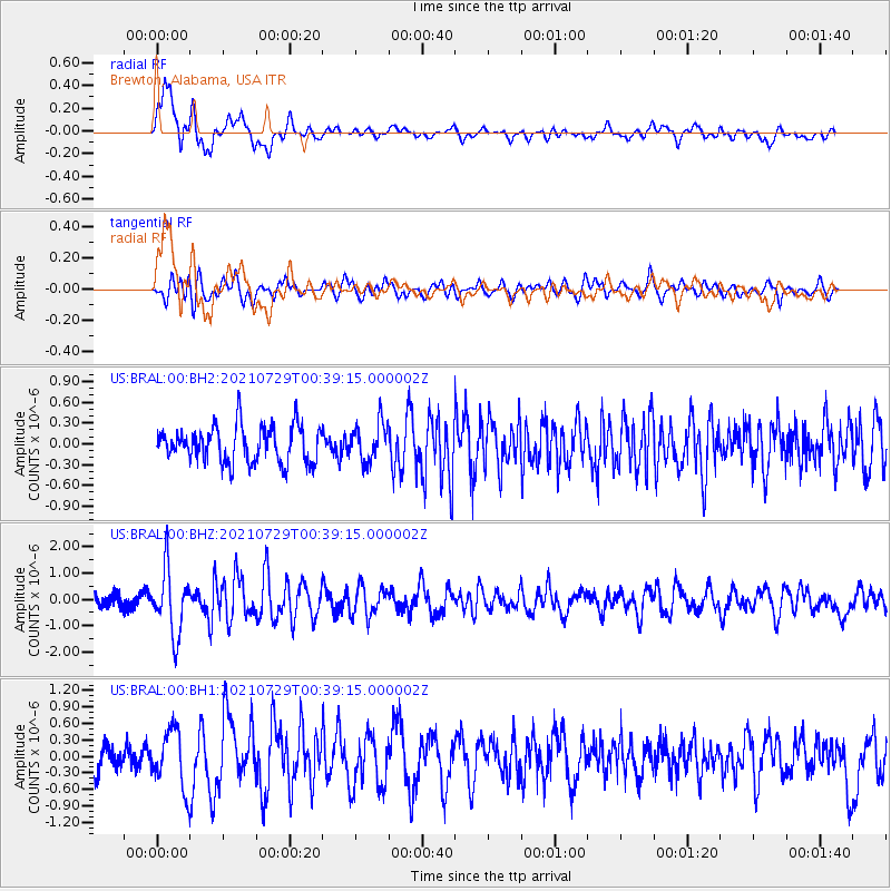
| Radial Match: |
83.75058 % |
| Radial Bump: |
400 |
| Transverse Match: |
59.295334 % |
| Transverse Bump: |
400 |
| SOD ConfigId: |
25131211 |
| Insert Time: |
2021-08-12 00:59:44.099 +0000 |
| GWidth: |
2.5 |
| Max Bumps: |
400 |
| Tol: |
0.001 |
|
Signal To Noise
| Channel | StoN | STA | LTA |
| US:BRAL:00:BHZ:20210729T00:39:15.000002Z | 5.907663 | 1.2012664E-6 | 2.0334036E-7 |
| US:BRAL:00:BH1:20210729T00:39:15.000002Z | 2.347048 | 5.2854193E-7 | 2.2519433E-7 |
| US:BRAL:00:BH2:20210729T00:39:15.000002Z | 1.0632292 | 2.7690277E-7 | 2.6043566E-7 |
| Arrivals |
| Ps | 2.0 SECOND |
| PpPs | 5.4 SECOND |
| PsPs/PpSs | 7.4 SECOND |


