You are here: Home > Network List > US - United States National Seismic Network Stations List
> Station MSO Missoula, Montana, USA > Earthquake Result Viewer
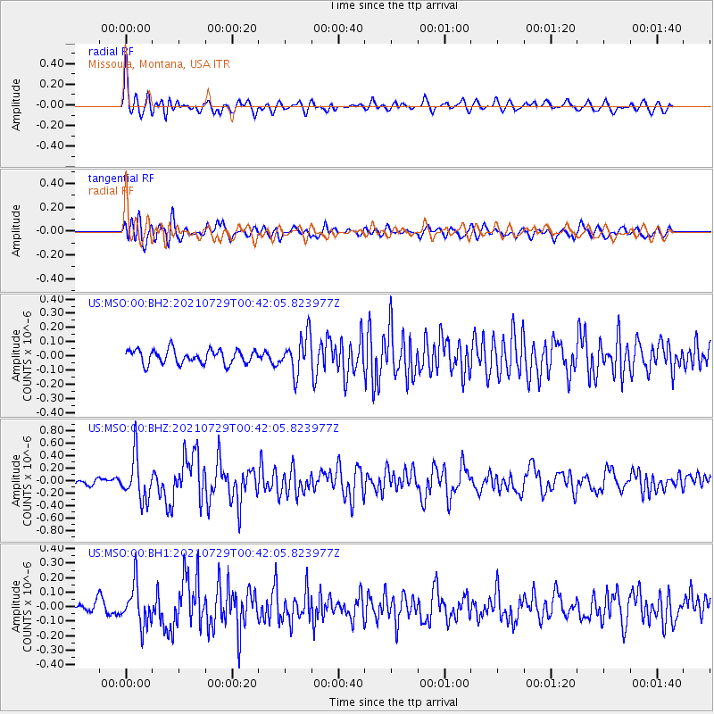
MSO Missoula, Montana, USA - Earthquake Result Viewer
*The percent match for this event was below the threshold and hence no stack was calculated.
| Earthquake location: |
Near Coast Of Northern Peru |
| Earthquake latitude/longitude: |
-8.3/-80.0 |
| Earthquake time(UTC): |
2021/07/29 (210) 00:32:13 GMT |
| Earthquake Depth: |
23 km |
| Earthquake Magnitude: |
5.8 Mww |
| Earthquake Catalog/Contributor: |
NEIC PDE/us |
|
| Network: |
US United States National Seismic Network |
| Station: |
MSO Missoula, Montana, USA |
| Lat/Lon: |
46.83 N/113.94 W |
| Elevation: |
1264 m |
|
| Distance: |
62.7 deg |
| Az: |
334.418 deg |
| Baz: |
141.514 deg |
| Ray Param: |
$rayparam |
*The percent match for this event was below the threshold and hence was not used in the summary stack. |
|
| Radial Match: |
78.51103 % |
| Radial Bump: |
400 |
| Transverse Match: |
70.788376 % |
| Transverse Bump: |
400 |
| SOD ConfigId: |
25131211 |
| Insert Time: |
2021-08-12 01:00:22.188 +0000 |
| GWidth: |
2.5 |
| Max Bumps: |
400 |
| Tol: |
0.001 |
|
Signal To Noise
| Channel | StoN | STA | LTA |
| US:MSO:00:BHZ:20210729T00:42:05.823977Z | 5.2549963 | 3.4917375E-7 | 6.644605E-8 |
| US:MSO:00:BH1:20210729T00:42:05.823977Z | 4.4174876 | 1.4171886E-7 | 3.2081324E-8 |
| US:MSO:00:BH2:20210729T00:42:05.823977Z | 2.7276878 | 1.3349971E-7 | 4.8942447E-8 |
| Arrivals |
| Ps | |
| PpPs | |
| PsPs/PpSs | |


