You are here: Home > Network List > US - United States National Seismic Network Stations List
> Station OGNE Ogallala, Nebraska, USA > Earthquake Result Viewer
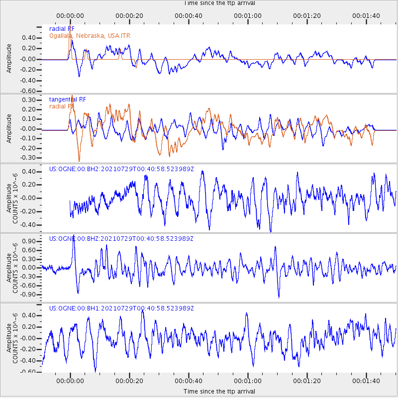
OGNE Ogallala, Nebraska, USA - Earthquake Result Viewer
*The percent match for this event was below the threshold and hence no stack was calculated.
| Earthquake location: |
Near Coast Of Northern Peru |
| Earthquake latitude/longitude: |
-8.3/-80.0 |
| Earthquake time(UTC): |
2021/07/29 (210) 00:32:13 GMT |
| Earthquake Depth: |
23 km |
| Earthquake Magnitude: |
5.8 Mww |
| Earthquake Catalog/Contributor: |
NEIC PDE/us |
|
| Network: |
US United States National Seismic Network |
| Station: |
OGNE Ogallala, Nebraska, USA |
| Lat/Lon: |
40.95 N/102.03 W |
| Elevation: |
1054 m |
|
| Distance: |
53.1 deg |
| Az: |
339.149 deg |
| Baz: |
152.291 deg |
| Ray Param: |
$rayparam |
*The percent match for this event was below the threshold and hence was not used in the summary stack. |
|
| Radial Match: |
54.641 % |
| Radial Bump: |
400 |
| Transverse Match: |
60.873432 % |
| Transverse Bump: |
400 |
| SOD ConfigId: |
25131211 |
| Insert Time: |
2021-08-12 01:00:30.314 +0000 |
| GWidth: |
2.5 |
| Max Bumps: |
400 |
| Tol: |
0.001 |
|
Signal To Noise
| Channel | StoN | STA | LTA |
| US:OGNE:00:BHZ:20210729T00:40:58.523989Z | 5.551266 | 4.5698135E-7 | 8.2320206E-8 |
| US:OGNE:00:BH1:20210729T00:40:58.523989Z | 1.0841496 | 2.0822576E-7 | 1.9206367E-7 |
| US:OGNE:00:BH2:20210729T00:40:58.523989Z | 1.4961841 | 1.8798717E-7 | 1.2564442E-7 |
| Arrivals |
| Ps | |
| PpPs | |
| PsPs/PpSs | |


