You are here: Home > Network List > WI - West Indies IPGP Network Stations List
> Station BIM Morne Bigot, Anses d'Arlets, Martinique > Earthquake Result Viewer
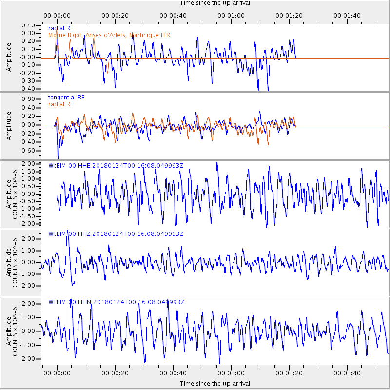
BIM Morne Bigot, Anses d'Arlets, Martinique - Earthquake Result Viewer
*The percent match for this event was below the threshold and hence no stack was calculated.
| Earthquake location: |
Gulf Of Alaska |
| Earthquake latitude/longitude: |
56.5/-148.5 |
| Earthquake time(UTC): |
2018/01/24 (024) 00:04:48 GMT |
| Earthquake Depth: |
10 km |
| Earthquake Magnitude: |
5.5 Mww |
| Earthquake Catalog/Contributor: |
NEIC PDE/us |
|
| Network: |
WI West Indies IPGP Network |
| Station: |
BIM Morne Bigot, Anses d'Arlets, Martinique |
| Lat/Lon: |
14.52 N/61.07 W |
| Elevation: |
391 m |
|
| Distance: |
76.6 deg |
| Az: |
83.975 deg |
| Baz: |
325.326 deg |
| Ray Param: |
$rayparam |
*The percent match for this event was below the threshold and hence was not used in the summary stack. |
|
| Radial Match: |
55.195137 % |
| Radial Bump: |
400 |
| Transverse Match: |
61.42514 % |
| Transverse Bump: |
400 |
| SOD ConfigId: |
2546091 |
| Insert Time: |
2018-02-07 00:10:32.336 +0000 |
| GWidth: |
2.5 |
| Max Bumps: |
400 |
| Tol: |
0.001 |
|
Signal To Noise
| Channel | StoN | STA | LTA |
| WI:BIM:00:HHZ:20180124T00:16:08.049993Z | 2.2631721 | 1.1880737E-6 | 5.249595E-7 |
| WI:BIM:00:HHN:20180124T00:16:08.049993Z | 1.2220522 | 8.429865E-7 | 6.8981217E-7 |
| WI:BIM:00:HHE:20180124T00:16:08.049993Z | 1.4712883 | 9.3611004E-7 | 6.362519E-7 |
| Arrivals |
| Ps | |
| PpPs | |
| PsPs/PpSs | |


