You are here: Home > Network List > BE - Belgian Seismic Network Stations List
> Station RCHB ROCHEFORT, BELGIUM > Earthquake Result Viewer
RCHB ROCHEFORT, BELGIUM - Earthquake Result Viewer
| Earthquake location: |
Alaska Peninsula |
| Earthquake latitude/longitude: |
55.3/-157.8 |
| Earthquake time(UTC): |
2021/07/29 (210) 06:15:45 GMT |
| Earthquake Depth: |
5.2 km |
| Earthquake Magnitude: |
7.3 ml |
| Earthquake Catalog/Contributor: |
NEIC PDE/ak |
|
| Network: |
BE Belgian Seismic Network |
| Station: |
RCHB ROCHEFORT, BELGIUM |
| Lat/Lon: |
50.16 N/5.23 E |
| Elevation: |
191 m |
|
| Distance: |
74.0 deg |
| Az: |
11.246 deg |
| Baz: |
350.017 deg |
| Ray Param: |
0.05267833 |
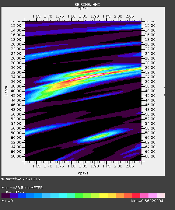
| Estimated Moho Depth: |
33.5 km |
| Estimated Crust Vp/Vs: |
1.88 |
| Assumed Crust Vp: |
6.276 km/s |
| Estimated Crust Vs: |
3.343 km/s |
| Estimated Crust Poisson's Ratio: |
0.30 |
|
| Radial Match: |
97.941216 % |
| Radial Bump: |
306 |
| Transverse Match: |
89.63876 % |
| Transverse Bump: |
400 |
| SOD ConfigId: |
25131211 |
| Insert Time: |
2021-08-12 06:17:15.395 +0000 |
| GWidth: |
2.5 |
| Max Bumps: |
400 |
| Tol: |
0.001 |
|

Signal To Noise
| Channel | StoN | STA | LTA |
| BE:RCHB: :HHZ:20210729T06:26:50.399996Z | 10.812641 | 9.021392E-6 | 8.3433747E-7 |
| BE:RCHB: :HHN:20210729T06:26:50.399996Z | 7.3057694 | 3.5872663E-6 | 4.910183E-7 |
| BE:RCHB: :HHE:20210729T06:26:50.399996Z | 8.604421 | 9.90213E-7 | 1.1508188E-7 |
| Arrivals |
| Ps | 4.8 SECOND |
| PpPs | 15 SECOND |
| PsPs/PpSs | 20 SECOND |


