You are here: Home > Network List > CA - Catalan Seismic Network Stations List
> Station CBRU Bruguera > Earthquake Result Viewer
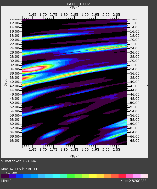
CBRU Bruguera - Earthquake Result Viewer
| Earthquake location: |
Alaska Peninsula |
| Earthquake latitude/longitude: |
55.3/-157.8 |
| Earthquake time(UTC): |
2021/07/29 (210) 06:15:45 GMT |
| Earthquake Depth: |
5.2 km |
| Earthquake Magnitude: |
7.3 ml |
| Earthquake Catalog/Contributor: |
NEIC PDE/ak |
|
| Network: |
CA Catalan Seismic Network |
| Station: |
CBRU Bruguera |
| Lat/Lon: |
42.28 N/2.18 E |
| Elevation: |
1327 m |
|
| Distance: |
81.3 deg |
| Az: |
14.87 deg |
| Baz: |
348.595 deg |
| Ray Param: |
0.047698207 |
| Estimated Moho Depth: |
33.5 km |
| Estimated Crust Vp/Vs: |
1.65 |
| Assumed Crust Vp: |
6.264 km/s |
| Estimated Crust Vs: |
3.796 km/s |
| Estimated Crust Poisson's Ratio: |
0.21 |
|
| Radial Match: |
95.074394 % |
| Radial Bump: |
400 |
| Transverse Match: |
92.63993 % |
| Transverse Bump: |
400 |
| SOD ConfigId: |
25131211 |
| Insert Time: |
2021-08-12 06:17:50.261 +0000 |
| GWidth: |
2.5 |
| Max Bumps: |
400 |
| Tol: |
0.001 |
|

Signal To Noise
| Channel | StoN | STA | LTA |
| CA:CBRU: :HHZ:20210729T06:27:31.259981Z | 4.811224 | 3.5081202E-6 | 7.291534E-7 |
| CA:CBRU: :HHN:20210729T06:27:31.259981Z | 2.4705873 | 8.502616E-7 | 3.4415362E-7 |
| CA:CBRU: :HHE:20210729T06:27:31.259981Z | 2.7091658 | 2.2716023E-7 | 8.3848775E-8 |
| Arrivals |
| Ps | 3.6 SECOND |
| PpPs | 14 SECOND |
| PsPs/PpSs | 17 SECOND |


