You are here: Home > Network List > CA - Catalan Seismic Network Stations List
> Station CFAR Far de la Banya > Earthquake Result Viewer
CFAR Far de la Banya - Earthquake Result Viewer
| Earthquake location: |
Alaska Peninsula |
| Earthquake latitude/longitude: |
55.3/-157.8 |
| Earthquake time(UTC): |
2021/07/29 (210) 06:15:45 GMT |
| Earthquake Depth: |
5.2 km |
| Earthquake Magnitude: |
7.3 ml |
| Earthquake Catalog/Contributor: |
NEIC PDE/ak |
|
| Network: |
CA Catalan Seismic Network |
| Station: |
CFAR Far de la Banya |
| Lat/Lon: |
40.56 N/0.66 E |
| Elevation: |
2.0 m |
|
| Distance: |
82.8 deg |
| Az: |
16.354 deg |
| Baz: |
347.801 deg |
| Ray Param: |
0.046681974 |
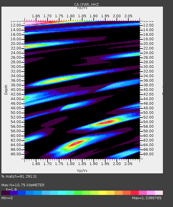
| Estimated Moho Depth: |
10.75 km |
| Estimated Crust Vp/Vs: |
1.60 |
| Assumed Crust Vp: |
6.391 km/s |
| Estimated Crust Vs: |
3.994 km/s |
| Estimated Crust Poisson's Ratio: |
0.18 |
|
| Radial Match: |
91.29131 % |
| Radial Bump: |
400 |
| Transverse Match: |
87.27597 % |
| Transverse Bump: |
400 |
| SOD ConfigId: |
25131211 |
| Insert Time: |
2021-08-12 06:17:53.722 +0000 |
| GWidth: |
2.5 |
| Max Bumps: |
400 |
| Tol: |
0.001 |
|

Signal To Noise
| Channel | StoN | STA | LTA |
| CA:CFAR: :HHZ:20210729T06:27:38.860018Z | 3.6877558 | 5.1763536E-6 | 1.4036596E-6 |
| CA:CFAR: :HHN:20210729T06:27:38.860018Z | 1.4360543 | 2.2665297E-6 | 1.5783036E-6 |
| CA:CFAR: :HHE:20210729T06:27:38.860018Z | 0.88816375 | 1.5560469E-6 | 1.751982E-6 |
| Arrivals |
| Ps | 1.0 SECOND |
| PpPs | 4.2 SECOND |
| PsPs/PpSs | 5.3 SECOND |


