You are here: Home > Network List > CI - Caltech Regional Seismic Network Stations List
> Station CHF Chilao Flat Rngr Sta, Altadena, CA, USA > Earthquake Result Viewer
CHF Chilao Flat Rngr Sta, Altadena, CA, USA - Earthquake Result Viewer
| Earthquake location: |
Alaska Peninsula |
| Earthquake latitude/longitude: |
55.3/-157.8 |
| Earthquake time(UTC): |
2021/07/29 (210) 06:15:45 GMT |
| Earthquake Depth: |
5.2 km |
| Earthquake Magnitude: |
7.3 ml |
| Earthquake Catalog/Contributor: |
NEIC PDE/ak |
|
| Network: |
CI Caltech Regional Seismic Network |
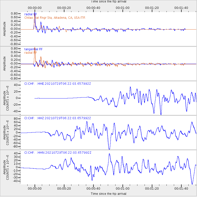
| Station: |
CHF Chilao Flat Rngr Sta, Altadena, CA, USA |
| Lat/Lon: |
34.33 N/118.03 W |
| Elevation: |
1594 m |
|
| Distance: |
34.5 deg |
| Az: |
110.737 deg |
| Baz: |
319.747 deg |
| Ray Param: |
0.077724546 |
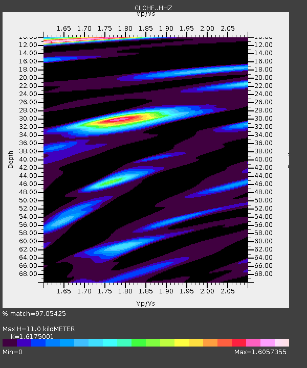
| Estimated Moho Depth: |
11.0 km |
| Estimated Crust Vp/Vs: |
1.62 |
| Assumed Crust Vp: |
6.1 km/s |
| Estimated Crust Vs: |
3.771 km/s |
| Estimated Crust Poisson's Ratio: |
0.19 |
|
| Radial Match: |
97.05425 % |
| Radial Bump: |
308 |
| Transverse Match: |
89.178375 % |
| Transverse Bump: |
400 |
| SOD ConfigId: |
25131211 |
| Insert Time: |
2021-08-12 06:18:36.072 +0000 |
| GWidth: |
2.5 |
| Max Bumps: |
400 |
| Tol: |
0.001 |
|
Signal To Noise
| Channel | StoN | STA | LTA |
| CI:CHF: :HHZ:20210729T06:22:03.657992Z | 8.034671 | 5.023485E-6 | 6.2522594E-7 |
| CI:CHF: :HHN:20210729T06:22:03.657992Z | 9.7996435 | 2.8600368E-6 | 2.918511E-7 |
| CI:CHF: :HHE:20210729T06:22:03.657992Z | 9.893399 | 2.51814E-6 | 2.545273E-7 |
| Arrivals |
| Ps | 1.2 SECOND |
| PpPs | 4.4 SECOND |
| PsPs/PpSs | 5.6 SECOND |


