You are here: Home > Network List > CI - Caltech Regional Seismic Network Stations List
> Station GLA Glamis, Glamis, CA, USA > Earthquake Result Viewer
GLA Glamis, Glamis, CA, USA - Earthquake Result Viewer
| Earthquake location: |
Alaska Peninsula |
| Earthquake latitude/longitude: |
55.3/-157.8 |
| Earthquake time(UTC): |
2021/07/29 (210) 06:15:45 GMT |
| Earthquake Depth: |
5.2 km |
| Earthquake Magnitude: |
7.3 ml |
| Earthquake Catalog/Contributor: |
NEIC PDE/ak |
|
| Network: |
CI Caltech Regional Seismic Network |
| Station: |
GLA Glamis, Glamis, CA, USA |
| Lat/Lon: |
33.05 N/114.83 W |
| Elevation: |
610 m |
|
| Distance: |
37.2 deg |
| Az: |
108.668 deg |
| Baz: |
319.836 deg |
| Ray Param: |
0.076294646 |
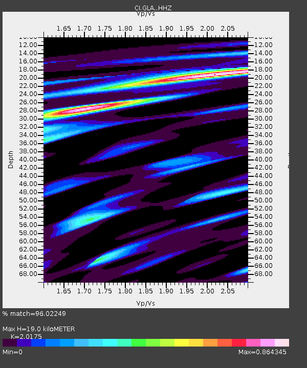
| Estimated Moho Depth: |
19.0 km |
| Estimated Crust Vp/Vs: |
2.02 |
| Assumed Crust Vp: |
6.155 km/s |
| Estimated Crust Vs: |
3.051 km/s |
| Estimated Crust Poisson's Ratio: |
0.34 |
|
| Radial Match: |
96.02249 % |
| Radial Bump: |
330 |
| Transverse Match: |
81.65001 % |
| Transverse Bump: |
400 |
| SOD ConfigId: |
25131211 |
| Insert Time: |
2021-08-12 06:18:53.099 +0000 |
| GWidth: |
2.5 |
| Max Bumps: |
400 |
| Tol: |
0.001 |
|

Signal To Noise
| Channel | StoN | STA | LTA |
| CI:GLA: :HHZ:20210729T06:22:26.743014Z | 5.6392937 | 3.2321445E-6 | 5.73147E-7 |
| CI:GLA: :HHN:20210729T06:22:26.743014Z | 5.2853303 | 2.0063608E-6 | 3.7960933E-7 |
| CI:GLA: :HHE:20210729T06:22:26.743014Z | 5.668215 | 1.8444769E-6 | 3.25407E-7 |
| Arrivals |
| Ps | 3.3 SECOND |
| PpPs | 8.8 SECOND |
| PsPs/PpSs | 12 SECOND |


