You are here: Home > Network List > CI - Caltech Regional Seismic Network Stations List
> Station SBC Santa Barbara, Santa Barbara, CA, USA > Earthquake Result Viewer
SBC Santa Barbara, Santa Barbara, CA, USA - Earthquake Result Viewer
| Earthquake location: |
Alaska Peninsula |
| Earthquake latitude/longitude: |
55.3/-157.8 |
| Earthquake time(UTC): |
2021/07/29 (210) 06:15:45 GMT |
| Earthquake Depth: |
5.2 km |
| Earthquake Magnitude: |
7.3 ml |
| Earthquake Catalog/Contributor: |
NEIC PDE/ak |
|
| Network: |
CI Caltech Regional Seismic Network |
| Station: |
SBC Santa Barbara, Santa Barbara, CA, USA |
| Lat/Lon: |
34.44 N/119.71 W |
| Elevation: |
94 m |
|
| Distance: |
33.5 deg |
| Az: |
112.527 deg |
| Baz: |
320.281 deg |
| Ray Param: |
0.07819466 |
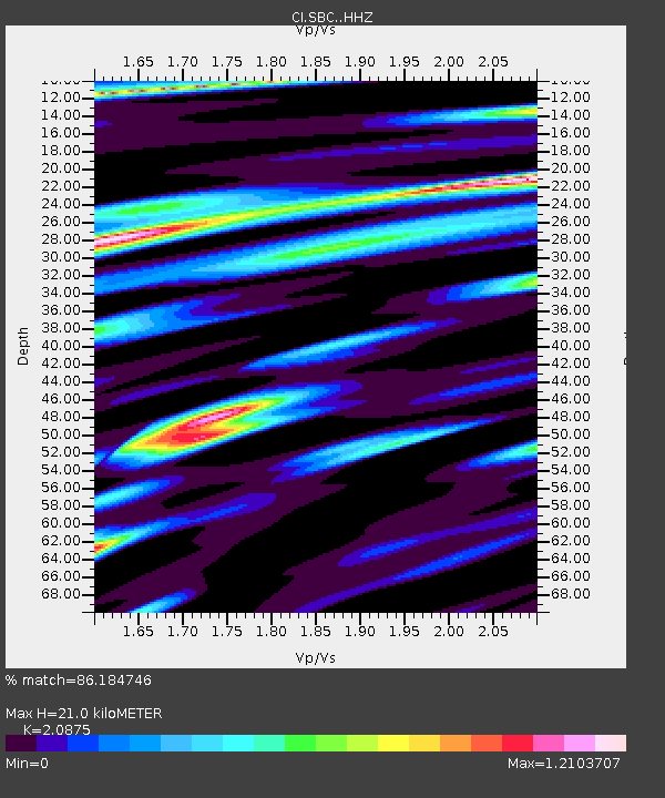
| Estimated Moho Depth: |
21.0 km |
| Estimated Crust Vp/Vs: |
2.09 |
| Assumed Crust Vp: |
6.1 km/s |
| Estimated Crust Vs: |
2.922 km/s |
| Estimated Crust Poisson's Ratio: |
0.35 |
|
| Radial Match: |
86.184746 % |
| Radial Bump: |
400 |
| Transverse Match: |
90.000885 % |
| Transverse Bump: |
400 |
| SOD ConfigId: |
25131211 |
| Insert Time: |
2021-08-12 06:19:36.579 +0000 |
| GWidth: |
2.5 |
| Max Bumps: |
400 |
| Tol: |
0.001 |
|

Signal To Noise
| Channel | StoN | STA | LTA |
| CI:SBC: :HHZ:20210729T06:21:55.168001Z | 5.560908 | 4.0996E-6 | 7.372178E-7 |
| CI:SBC: :HHN:20210729T06:21:55.168001Z | 3.8153498 | 2.4954963E-6 | 6.540675E-7 |
| CI:SBC: :HHE:20210729T06:21:55.168001Z | 2.8545723 | 1.841441E-6 | 6.4508475E-7 |
| Arrivals |
| Ps | 4.0 SECOND |
| PpPs | 10 SECOND |
| PsPs/PpSs | 14 SECOND |


