You are here: Home > Network List > CN - Canadian National Seismograph Network Stations List
> Station A61 Sainte Mathilde, QC, CA > Earthquake Result Viewer
A61 Sainte Mathilde, QC, CA - Earthquake Result Viewer
| Earthquake location: |
Alaska Peninsula |
| Earthquake latitude/longitude: |
55.3/-157.8 |
| Earthquake time(UTC): |
2021/07/29 (210) 06:15:45 GMT |
| Earthquake Depth: |
5.2 km |
| Earthquake Magnitude: |
7.3 ml |
| Earthquake Catalog/Contributor: |
NEIC PDE/ak |
|
| Network: |
CN Canadian National Seismograph Network |
| Station: |
A61 Sainte Mathilde, QC, CA |
| Lat/Lon: |
47.69 N/70.09 W |
| Elevation: |
380 m |
|
| Distance: |
51.7 deg |
| Az: |
59.37 deg |
| Baz: |
313.259 deg |
| Ray Param: |
0.06727673 |
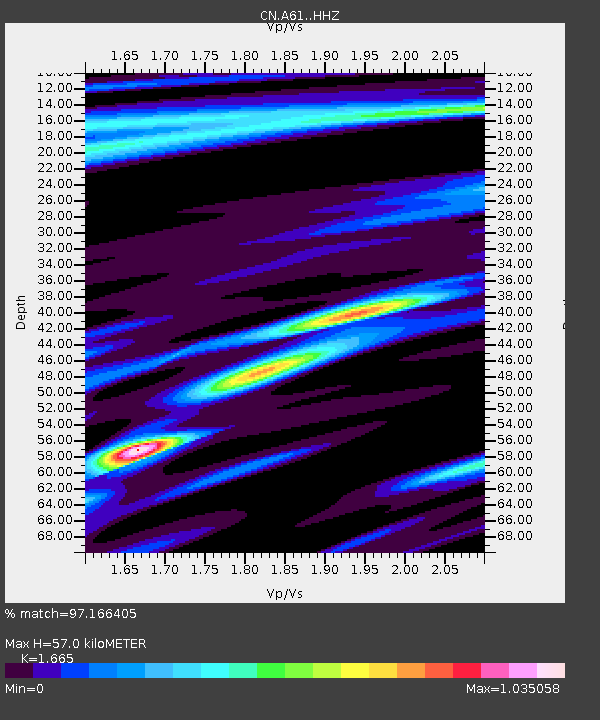
| Estimated Moho Depth: |
57.0 km |
| Estimated Crust Vp/Vs: |
1.66 |
| Assumed Crust Vp: |
6.61 km/s |
| Estimated Crust Vs: |
3.97 km/s |
| Estimated Crust Poisson's Ratio: |
0.22 |
|
| Radial Match: |
97.166405 % |
| Radial Bump: |
236 |
| Transverse Match: |
88.03093 % |
| Transverse Bump: |
400 |
| SOD ConfigId: |
25131211 |
| Insert Time: |
2021-08-12 06:20:10.947 +0000 |
| GWidth: |
2.5 |
| Max Bumps: |
400 |
| Tol: |
0.001 |
|

Signal To Noise
| Channel | StoN | STA | LTA |
| CN:A61: :HHZ:20210729T06:24:22.230013Z | 11.00497 | 5.1737393E-6 | 4.7012753E-7 |
| CN:A61: :HHN:20210729T06:24:22.230013Z | 7.5778513 | 1.6643744E-6 | 2.1963672E-7 |
| CN:A61: :HHE:20210729T06:24:22.230013Z | 7.2574773 | 1.849336E-6 | 2.5481802E-7 |
| Arrivals |
| Ps | 6.1 SECOND |
| PpPs | 22 SECOND |
| PsPs/PpSs | 28 SECOND |


