You are here: Home > Network List > CN - Canadian National Seismograph Network Stations List
> Station CHEG Cheticamp, NS, CA > Earthquake Result Viewer
CHEG Cheticamp, NS, CA - Earthquake Result Viewer
| Earthquake location: |
Alaska Peninsula |
| Earthquake latitude/longitude: |
55.3/-157.8 |
| Earthquake time(UTC): |
2021/07/29 (210) 06:15:45 GMT |
| Earthquake Depth: |
5.2 km |
| Earthquake Magnitude: |
7.3 ml |
| Earthquake Catalog/Contributor: |
NEIC PDE/ak |
|
| Network: |
CN Canadian National Seismograph Network |
| Station: |
CHEG Cheticamp, NS, CA |
| Lat/Lon: |
46.81 N/60.67 W |
| Elevation: |
446 m |
|
| Distance: |
56.8 deg |
| Az: |
54.522 deg |
| Baz: |
317.324 deg |
| Ray Param: |
0.06390705 |
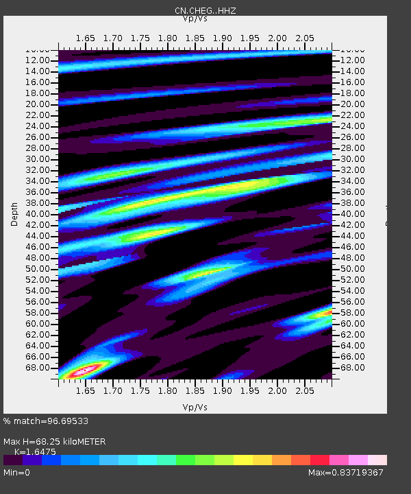
| Estimated Moho Depth: |
68.25 km |
| Estimated Crust Vp/Vs: |
1.65 |
| Assumed Crust Vp: |
6.291 km/s |
| Estimated Crust Vs: |
3.818 km/s |
| Estimated Crust Poisson's Ratio: |
0.21 |
|
| Radial Match: |
96.69533 % |
| Radial Bump: |
322 |
| Transverse Match: |
89.16349 % |
| Transverse Bump: |
400 |
| SOD ConfigId: |
25131211 |
| Insert Time: |
2021-08-12 06:20:21.574 +0000 |
| GWidth: |
2.5 |
| Max Bumps: |
400 |
| Tol: |
0.001 |
|

Signal To Noise
| Channel | StoN | STA | LTA |
| CN:CHEG: :HHZ:20210729T06:24:59.629977Z | 9.726415 | 5.82009E-6 | 5.9837976E-7 |
| CN:CHEG: :HHN:20210729T06:24:59.629977Z | 6.9518595 | 2.300527E-6 | 3.3092257E-7 |
| CN:CHEG: :HHE:20210729T06:24:59.629977Z | 5.678561 | 1.235091E-6 | 2.1750068E-7 |
| Arrivals |
| Ps | 7.4 SECOND |
| PpPs | 27 SECOND |
| PsPs/PpSs | 35 SECOND |


