You are here: Home > Network List > CN - Canadian National Seismograph Network Stations List
> Station TBO Thunder Bay, ON, CA > Earthquake Result Viewer
TBO Thunder Bay, ON, CA - Earthquake Result Viewer
| Earthquake location: |
Alaska Peninsula |
| Earthquake latitude/longitude: |
55.3/-157.8 |
| Earthquake time(UTC): |
2021/07/29 (210) 06:15:45 GMT |
| Earthquake Depth: |
5.2 km |
| Earthquake Magnitude: |
7.3 ml |
| Earthquake Catalog/Contributor: |
NEIC PDE/ak |
|
| Network: |
CN Canadian National Seismograph Network |
| Station: |
TBO Thunder Bay, ON, CA |
| Lat/Lon: |
48.65 N/89.41 W |
| Elevation: |
475 m |
|
| Distance: |
41.1 deg |
| Az: |
69.724 deg |
| Baz: |
306.03 deg |
| Ray Param: |
0.07401341 |
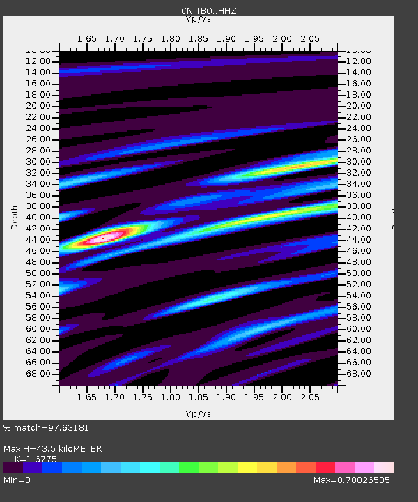
| Estimated Moho Depth: |
43.5 km |
| Estimated Crust Vp/Vs: |
1.68 |
| Assumed Crust Vp: |
6.467 km/s |
| Estimated Crust Vs: |
3.855 km/s |
| Estimated Crust Poisson's Ratio: |
0.22 |
|
| Radial Match: |
97.63181 % |
| Radial Bump: |
241 |
| Transverse Match: |
87.86077 % |
| Transverse Bump: |
400 |
| SOD ConfigId: |
25131211 |
| Insert Time: |
2021-08-12 06:21:13.666 +0000 |
| GWidth: |
2.5 |
| Max Bumps: |
400 |
| Tol: |
0.001 |
|

Signal To Noise
| Channel | StoN | STA | LTA |
| CN:TBO: :HHZ:20210729T06:22:59.339999Z | 3.6143472 | 1.6026256E-6 | 4.4340663E-7 |
| CN:TBO: :HHN:20210729T06:22:59.339999Z | 2.238953 | 4.687478E-7 | 2.0936025E-7 |
| CN:TBO: :HHE:20210729T06:22:59.339999Z | 2.7681098 | 7.71389E-7 | 2.7866997E-7 |
| Arrivals |
| Ps | 4.9 SECOND |
| PpPs | 17 SECOND |
| PsPs/PpSs | 22 SECOND |


