You are here: Home > Network List > G - GEOSCOPE Stations List
> Station IVI Ivittuut, Greenland > Earthquake Result Viewer
IVI Ivittuut, Greenland - Earthquake Result Viewer
| Earthquake location: |
Alaska Peninsula |
| Earthquake latitude/longitude: |
55.3/-157.8 |
| Earthquake time(UTC): |
2021/07/29 (210) 06:15:45 GMT |
| Earthquake Depth: |
5.2 km |
| Earthquake Magnitude: |
7.3 ml |
| Earthquake Catalog/Contributor: |
NEIC PDE/ak |
|
| Network: |
G GEOSCOPE |
| Station: |
IVI Ivittuut, Greenland |
| Lat/Lon: |
61.21 N/48.17 W |
| Elevation: |
15 m |
|
| Distance: |
51.3 deg |
| Az: |
35.725 deg |
| Baz: |
316.405 deg |
| Ray Param: |
0.06749458 |
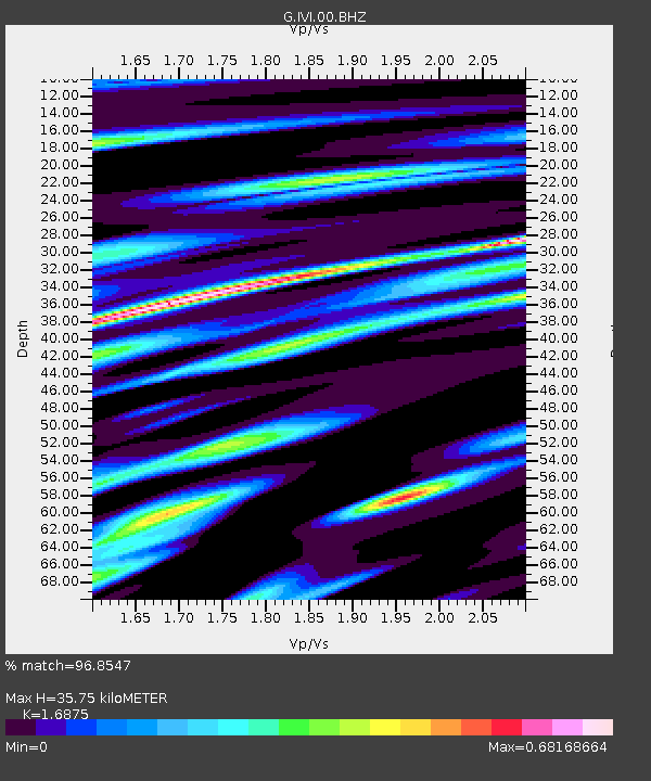
| Estimated Moho Depth: |
35.75 km |
| Estimated Crust Vp/Vs: |
1.69 |
| Assumed Crust Vp: |
6.472 km/s |
| Estimated Crust Vs: |
3.835 km/s |
| Estimated Crust Poisson's Ratio: |
0.23 |
|
| Radial Match: |
96.8547 % |
| Radial Bump: |
353 |
| Transverse Match: |
88.39717 % |
| Transverse Bump: |
400 |
| SOD ConfigId: |
25131211 |
| Insert Time: |
2021-08-12 06:22:37.280 +0000 |
| GWidth: |
2.5 |
| Max Bumps: |
400 |
| Tol: |
0.001 |
|
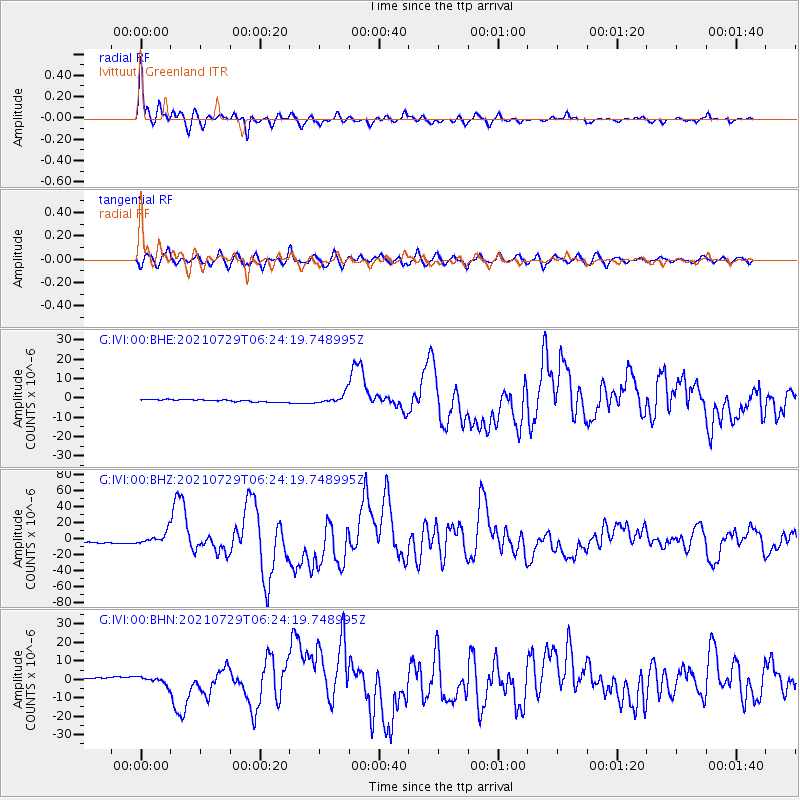
Signal To Noise
| Channel | StoN | STA | LTA |
| G:IVI:00:BHZ:20210729T06:24:19.748995Z | 5.6657867 | 7.664765E-6 | 1.3528157E-6 |
| G:IVI:00:BHN:20210729T06:24:19.748995Z | 3.2809117 | 2.134275E-6 | 6.505128E-7 |
| G:IVI:00:BHE:20210729T06:24:19.748995Z | 4.395925 | 2.5682825E-6 | 5.8424166E-7 |
| Arrivals |
| Ps | 4.0 SECOND |
| PpPs | 14 SECOND |
| PsPs/PpSs | 18 SECOND |


