You are here: Home > Network List > G - GEOSCOPE Stations List
> Station KIP Kipapa, Hawai, U.S.A. (Pacific Ocean) > Earthquake Result Viewer
KIP Kipapa, Hawai, U.S.A. (Pacific Ocean) - Earthquake Result Viewer

| Earthquake location: |
Alaska Peninsula |
| Earthquake latitude/longitude: |
55.3/-157.8 |
| Earthquake time(UTC): |
2021/07/29 (210) 06:15:45 GMT |
| Earthquake Depth: |
5.2 km |
| Earthquake Magnitude: |
7.3 ml |
| Earthquake Catalog/Contributor: |
NEIC PDE/ak |
|
| Network: |
G GEOSCOPE |
| Station: |
KIP Kipapa, Hawai, U.S.A. (Pacific Ocean) |
| Lat/Lon: |
21.42 N/158.01 W |
| Elevation: |
70 m |
|
| Distance: |
33.8 deg |
| Az: |
180.309 deg |
| Baz: |
0.189 deg |
| Ray Param: |
0.0780506 |
| Estimated Moho Depth: |
26.25 km |
| Estimated Crust Vp/Vs: |
1.95 |
| Assumed Crust Vp: |
4.24 km/s |
| Estimated Crust Vs: |
2.172 km/s |
| Estimated Crust Poisson's Ratio: |
0.32 |
|
| Radial Match: |
95.065796 % |
| Radial Bump: |
361 |
| Transverse Match: |
86.0507 % |
| Transverse Bump: |
400 |
| SOD ConfigId: |
25131211 |
| Insert Time: |
2021-08-12 06:22:37.670 +0000 |
| GWidth: |
2.5 |
| Max Bumps: |
400 |
| Tol: |
0.001 |
|
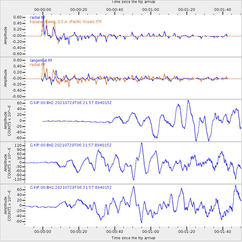
Signal To Noise
| Channel | StoN | STA | LTA |
| G:KIP:00:BHZ:20210729T06:21:57.894015Z | 3.9660258 | 5.3415065E-6 | 1.3468158E-6 |
| G:KIP:00:BH1:20210729T06:21:57.894015Z | 3.198161 | 3.468658E-6 | 1.0845789E-6 |
| G:KIP:00:BH2:20210729T06:21:57.894015Z | 4.357381 | 3.4709658E-6 | 7.9657156E-7 |
| Arrivals |
| Ps | 6.1 SECOND |
| PpPs | 18 SECOND |
| PsPs/PpSs | 24 SECOND |


