You are here: Home > Network List > GB - Great Britain Seismograph Network Stations List
> Station CCA1 CARNMENELLIS, ENGLAND > Earthquake Result Viewer
CCA1 CARNMENELLIS, ENGLAND - Earthquake Result Viewer
| Earthquake location: |
Alaska Peninsula |
| Earthquake latitude/longitude: |
55.3/-157.8 |
| Earthquake time(UTC): |
2021/07/29 (210) 06:15:45 GMT |
| Earthquake Depth: |
5.2 km |
| Earthquake Magnitude: |
7.3 ml |
| Earthquake Catalog/Contributor: |
NEIC PDE/ak |
|
| Network: |
GB Great Britain Seismograph Network |
| Station: |
CCA1 CARNMENELLIS, ENGLAND |
| Lat/Lon: |
50.19 N/5.23 W |
| Elevation: |
209 m |
|
| Distance: |
72.4 deg |
| Az: |
18.077 deg |
| Baz: |
343.979 deg |
| Ray Param: |
0.05368609 |
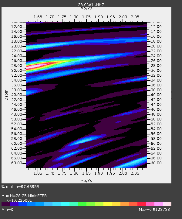
| Estimated Moho Depth: |
28.25 km |
| Estimated Crust Vp/Vs: |
1.62 |
| Assumed Crust Vp: |
6.24 km/s |
| Estimated Crust Vs: |
3.846 km/s |
| Estimated Crust Poisson's Ratio: |
0.19 |
|
| Radial Match: |
97.68958 % |
| Radial Bump: |
300 |
| Transverse Match: |
89.40397 % |
| Transverse Bump: |
400 |
| SOD ConfigId: |
25131211 |
| Insert Time: |
2021-08-12 06:22:42.502 +0000 |
| GWidth: |
2.5 |
| Max Bumps: |
400 |
| Tol: |
0.001 |
|

Signal To Noise
| Channel | StoN | STA | LTA |
| GB:CCA1: :HHZ:20210729T06:26:41.300021Z | 4.829313 | 6.2600666E-6 | 1.2962645E-6 |
| GB:CCA1: :HHN:20210729T06:26:41.300021Z | 3.7025156 | 2.5580903E-6 | 6.90906E-7 |
| GB:CCA1: :HHE:20210729T06:26:41.300021Z | 2.2961168 | 7.88058E-7 | 3.4321337E-7 |
| Arrivals |
| Ps | 2.9 SECOND |
| PpPs | 11 SECOND |
| PsPs/PpSs | 14 SECOND |


