You are here: Home > Network List > GB - Great Britain Seismograph Network Stations List
> Station EDMD EDMUNDBYERS, ENGLAND > Earthquake Result Viewer
EDMD EDMUNDBYERS, ENGLAND - Earthquake Result Viewer
| Earthquake location: |
Alaska Peninsula |
| Earthquake latitude/longitude: |
55.3/-157.8 |
| Earthquake time(UTC): |
2021/07/29 (210) 06:15:45 GMT |
| Earthquake Depth: |
5.2 km |
| Earthquake Magnitude: |
7.3 ml |
| Earthquake Catalog/Contributor: |
NEIC PDE/ak |
|
| Network: |
GB Great Britain Seismograph Network |
| Station: |
EDMD EDMUNDBYERS, ENGLAND |
| Lat/Lon: |
54.83 N/1.96 W |
| Elevation: |
337 m |
|
| Distance: |
68.5 deg |
| Az: |
14.734 deg |
| Baz: |
345.444 deg |
| Ray Param: |
0.056303084 |
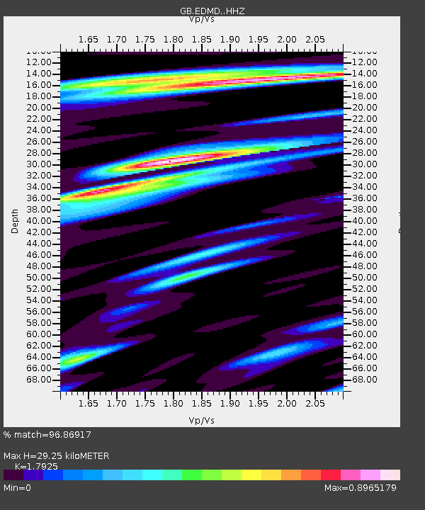
| Estimated Moho Depth: |
29.25 km |
| Estimated Crust Vp/Vs: |
1.79 |
| Assumed Crust Vp: |
6.24 km/s |
| Estimated Crust Vs: |
3.481 km/s |
| Estimated Crust Poisson's Ratio: |
0.27 |
|
| Radial Match: |
96.86917 % |
| Radial Bump: |
400 |
| Transverse Match: |
90.35209 % |
| Transverse Bump: |
400 |
| SOD ConfigId: |
25131211 |
| Insert Time: |
2021-08-12 06:22:50.763 +0000 |
| GWidth: |
2.5 |
| Max Bumps: |
400 |
| Tol: |
0.001 |
|

Signal To Noise
| Channel | StoN | STA | LTA |
| GB:EDMD: :HHZ:20210729T06:26:17.160006Z | 7.70564 | 9.843158E-6 | 1.2773967E-6 |
| GB:EDMD: :HHN:20210729T06:26:17.160006Z | 6.358298 | 4.551752E-6 | 7.158759E-7 |
| GB:EDMD: :HHE:20210729T06:26:17.160006Z | 2.3664744 | 7.3640877E-7 | 3.1118392E-7 |
| Arrivals |
| Ps | 3.9 SECOND |
| PpPs | 13 SECOND |
| PsPs/PpSs | 16 SECOND |


