You are here: Home > Network List > GB - Great Britain Seismograph Network Stations List
> Station HPK HAVERAH PARK, ENGLAND > Earthquake Result Viewer
HPK HAVERAH PARK, ENGLAND - Earthquake Result Viewer
| Earthquake location: |
Alaska Peninsula |
| Earthquake latitude/longitude: |
55.3/-157.8 |
| Earthquake time(UTC): |
2021/07/29 (210) 06:15:45 GMT |
| Earthquake Depth: |
5.2 km |
| Earthquake Magnitude: |
7.3 ml |
| Earthquake Catalog/Contributor: |
NEIC PDE/ak |
|
| Network: |
GB Great Britain Seismograph Network |
| Station: |
HPK HAVERAH PARK, ENGLAND |
| Lat/Lon: |
53.96 N/1.62 W |
| Elevation: |
233 m |
|
| Distance: |
69.3 deg |
| Az: |
14.761 deg |
| Baz: |
345.729 deg |
| Ray Param: |
0.055718616 |
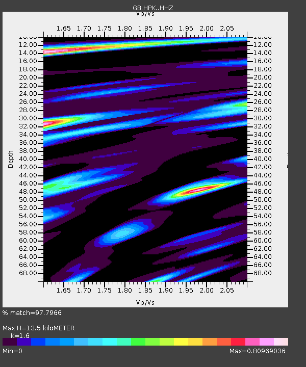
| Estimated Moho Depth: |
13.5 km |
| Estimated Crust Vp/Vs: |
1.60 |
| Assumed Crust Vp: |
6.276 km/s |
| Estimated Crust Vs: |
3.922 km/s |
| Estimated Crust Poisson's Ratio: |
0.18 |
|
| Radial Match: |
97.7966 % |
| Radial Bump: |
369 |
| Transverse Match: |
90.34646 % |
| Transverse Bump: |
400 |
| SOD ConfigId: |
25131211 |
| Insert Time: |
2021-08-12 06:22:59.285 +0000 |
| GWidth: |
2.5 |
| Max Bumps: |
400 |
| Tol: |
0.001 |
|

Signal To Noise
| Channel | StoN | STA | LTA |
| GB:HPK: :HHZ:20210729T06:26:22.720003Z | 9.026527 | 8.511107E-6 | 9.4289936E-7 |
| GB:HPK: :HHN:20210729T06:26:22.720003Z | 3.5057414 | 3.0100252E-6 | 8.5859875E-7 |
| GB:HPK: :HHE:20210729T06:26:22.720003Z | 1.8421742 | 8.6911894E-7 | 4.7178978E-7 |
| Arrivals |
| Ps | 1.3 SECOND |
| PpPs | 5.4 SECOND |
| PsPs/PpSs | 6.7 SECOND |


