You are here: Home > Network List > GM - US Geological Survey Networks Stations List
> Station NMP35 New Mexico Permian - Site# W3S5 > Earthquake Result Viewer
NMP35 New Mexico Permian - Site# W3S5 - Earthquake Result Viewer
| Earthquake location: |
Alaska Peninsula |
| Earthquake latitude/longitude: |
55.3/-157.8 |
| Earthquake time(UTC): |
2021/07/29 (210) 06:15:45 GMT |
| Earthquake Depth: |
5.2 km |
| Earthquake Magnitude: |
7.3 ml |
| Earthquake Catalog/Contributor: |
NEIC PDE/ak |
|
| Network: |
GM US Geological Survey Networks |
| Station: |
NMP35 New Mexico Permian - Site# W3S5 |
| Lat/Lon: |
32.35 N/103.72 W |
| Elevation: |
1071 m |
|
| Distance: |
43.9 deg |
| Az: |
98.512 deg |
| Baz: |
318.08 deg |
| Ray Param: |
0.07227138 |
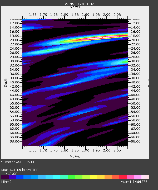
| Estimated Moho Depth: |
18.5 km |
| Estimated Crust Vp/Vs: |
1.98 |
| Assumed Crust Vp: |
6.129 km/s |
| Estimated Crust Vs: |
3.095 km/s |
| Estimated Crust Poisson's Ratio: |
0.33 |
|
| Radial Match: |
98.09583 % |
| Radial Bump: |
283 |
| Transverse Match: |
92.08632 % |
| Transverse Bump: |
400 |
| SOD ConfigId: |
25131211 |
| Insert Time: |
2021-08-12 06:23:45.016 +0000 |
| GWidth: |
2.5 |
| Max Bumps: |
400 |
| Tol: |
0.001 |
|

Signal To Noise
| Channel | StoN | STA | LTA |
| GM:NMP35:01:HHZ:20210729T06:23:21.964999Z | 6.5842266 | 1.8849081E-6 | 2.862763E-7 |
| GM:NMP35:01:HHN:20210729T06:23:21.964999Z | 3.1766553 | 8.319364E-7 | 2.6189068E-7 |
| GM:NMP35:01:HHE:20210729T06:23:21.964999Z | 4.85004 | 1.017996E-6 | 2.0989435E-7 |
| Arrivals |
| Ps | 3.1 SECOND |
| PpPs | 8.5 SECOND |
| PsPs/PpSs | 12 SECOND |


