You are here: Home > Network List > GO - National Seismic Network of Georgia Stations List
> Station BATM Batumi > Earthquake Result Viewer
BATM Batumi - Earthquake Result Viewer
| Earthquake location: |
Alaska Peninsula |
| Earthquake latitude/longitude: |
55.3/-157.8 |
| Earthquake time(UTC): |
2021/07/29 (210) 06:15:45 GMT |
| Earthquake Depth: |
5.2 km |
| Earthquake Magnitude: |
7.3 ml |
| Earthquake Catalog/Contributor: |
NEIC PDE/ak |
|
| Network: |
GO National Seismic Network of Georgia |
| Station: |
BATM Batumi |
| Lat/Lon: |
41.60 N/41.69 E |
| Elevation: |
298 m |
|
| Distance: |
82.0 deg |
| Az: |
345.34 deg |
| Baz: |
11.125 deg |
| Ray Param: |
0.04717613 |
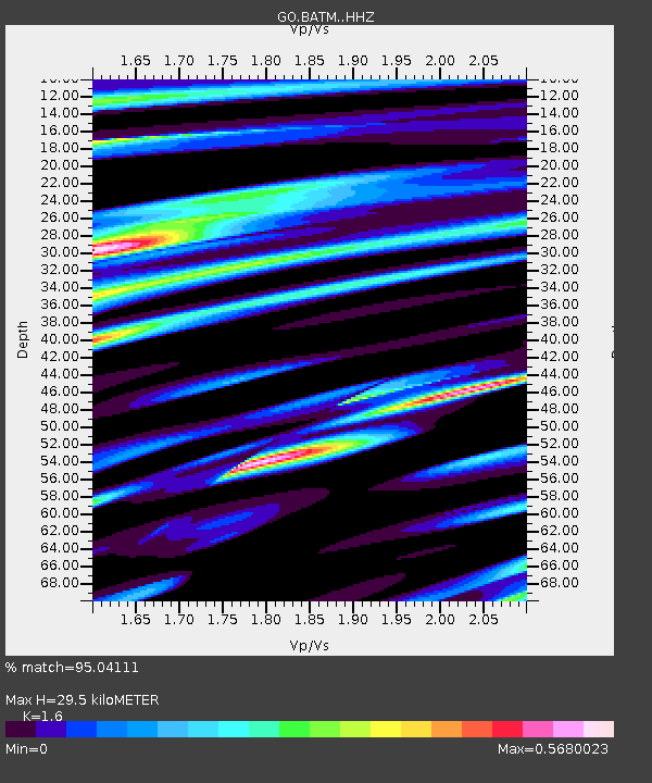
| Estimated Moho Depth: |
29.5 km |
| Estimated Crust Vp/Vs: |
1.60 |
| Assumed Crust Vp: |
6.401 km/s |
| Estimated Crust Vs: |
4.001 km/s |
| Estimated Crust Poisson's Ratio: |
0.18 |
|
| Radial Match: |
95.04111 % |
| Radial Bump: |
355 |
| Transverse Match: |
89.20215 % |
| Transverse Bump: |
400 |
| SOD ConfigId: |
25131211 |
| Insert Time: |
2021-08-12 06:23:53.264 +0000 |
| GWidth: |
2.5 |
| Max Bumps: |
400 |
| Tol: |
0.001 |
|

Signal To Noise
| Channel | StoN | STA | LTA |
| GO:BATM: :HHZ:20210729T06:27:35.129977Z | 79.73135 | 1.0402888E-5 | 1.3047423E-7 |
| GO:BATM: :HHN:20210729T06:27:35.129977Z | 11.127949 | 4.117024E-6 | 3.699715E-7 |
| GO:BATM: :HHE:20210729T06:27:35.129977Z | 1.1879584 | 4.6419322E-7 | 3.9074874E-7 |
| Arrivals |
| Ps | 2.8 SECOND |
| PpPs | 12 SECOND |
| PsPs/PpSs | 14 SECOND |


