You are here: Home > Network List > GS - US Geological Survey Networks Stations List
> Station OK051 E0350 and S34600 roads, Ralston OK > Earthquake Result Viewer
OK051 E0350 and S34600 roads, Ralston OK - Earthquake Result Viewer
| Earthquake location: |
Alaska Peninsula |
| Earthquake latitude/longitude: |
55.3/-157.8 |
| Earthquake time(UTC): |
2021/07/29 (210) 06:15:45 GMT |
| Earthquake Depth: |
5.2 km |
| Earthquake Magnitude: |
7.3 ml |
| Earthquake Catalog/Contributor: |
NEIC PDE/ak |
|
| Network: |
GS US Geological Survey Networks |
| Station: |
OK051 E0350 and S34600 roads, Ralston OK |
| Lat/Lon: |
36.50 N/96.84 W |
| Elevation: |
263 m |
|
| Distance: |
44.8 deg |
| Az: |
88.525 deg |
| Baz: |
314.814 deg |
| Ray Param: |
0.071698695 |
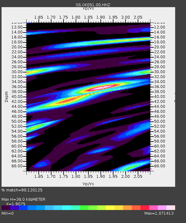
| Estimated Moho Depth: |
36.0 km |
| Estimated Crust Vp/Vs: |
1.91 |
| Assumed Crust Vp: |
6.483 km/s |
| Estimated Crust Vs: |
3.398 km/s |
| Estimated Crust Poisson's Ratio: |
0.31 |
|
| Radial Match: |
98.120125 % |
| Radial Bump: |
358 |
| Transverse Match: |
88.50631 % |
| Transverse Bump: |
400 |
| SOD ConfigId: |
25131211 |
| Insert Time: |
2021-08-12 06:24:22.203 +0000 |
| GWidth: |
2.5 |
| Max Bumps: |
400 |
| Tol: |
0.001 |
|

Signal To Noise
| Channel | StoN | STA | LTA |
| GS:OK051:00:HHZ:20210729T06:23:29.389986Z | 6.140731 | 1.5970958E-6 | 2.6008237E-7 |
| GS:OK051:00:HH1:20210729T06:23:29.389986Z | 1.7052255 | 9.004873E-8 | 5.280752E-8 |
| GS:OK051:00:HH2:20210729T06:23:29.389986Z | 5.500659 | 1.1388759E-6 | 2.0704354E-7 |
| Arrivals |
| Ps | 5.4 SECOND |
| PpPs | 15 SECOND |
| PsPs/PpSs | 21 SECOND |


