You are here: Home > Network List > GS - US Geological Survey Networks Stations List
> Station PR02 PR02, Guayanilla > Earthquake Result Viewer
PR02 PR02, Guayanilla - Earthquake Result Viewer
| Earthquake location: |
Alaska Peninsula |
| Earthquake latitude/longitude: |
55.3/-157.8 |
| Earthquake time(UTC): |
2021/07/29 (210) 06:15:45 GMT |
| Earthquake Depth: |
5.2 km |
| Earthquake Magnitude: |
7.3 ml |
| Earthquake Catalog/Contributor: |
NEIC PDE/ak |
|
| Network: |
GS US Geological Survey Networks |
| Station: |
PR02 PR02, Guayanilla |
| Lat/Lon: |
18.01 N/66.77 W |
| Elevation: |
3.0 m |
|
| Distance: |
76.0 deg |
| Az: |
78.696 deg |
| Baz: |
323.901 deg |
| Ray Param: |
0.051309485 |
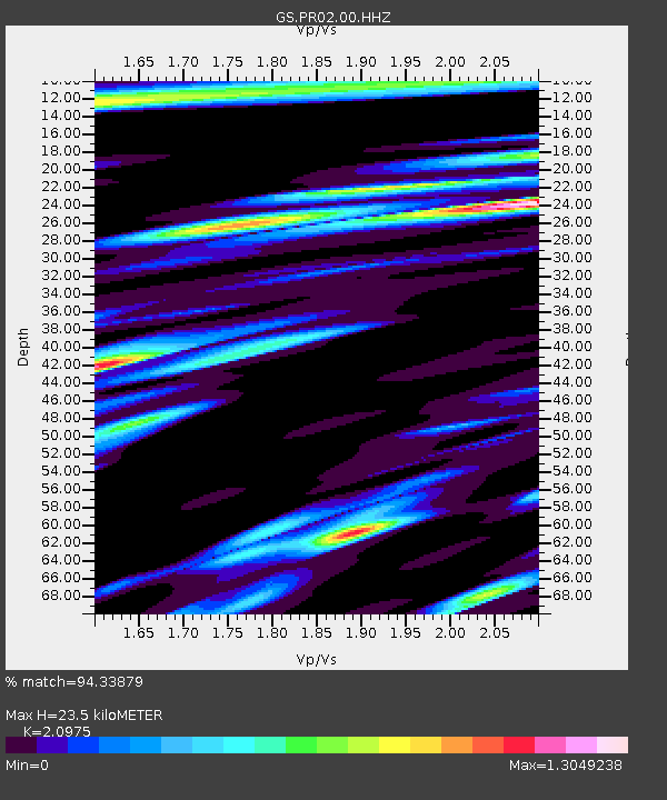
| Estimated Moho Depth: |
23.5 km |
| Estimated Crust Vp/Vs: |
2.10 |
| Assumed Crust Vp: |
5.14 km/s |
| Estimated Crust Vs: |
2.451 km/s |
| Estimated Crust Poisson's Ratio: |
0.35 |
|
| Radial Match: |
94.33879 % |
| Radial Bump: |
400 |
| Transverse Match: |
92.60906 % |
| Transverse Bump: |
400 |
| SOD ConfigId: |
25131211 |
| Insert Time: |
2021-08-12 06:24:26.745 +0000 |
| GWidth: |
2.5 |
| Max Bumps: |
400 |
| Tol: |
0.001 |
|

Signal To Noise
| Channel | StoN | STA | LTA |
| GS:PR02:00:HHZ:20210729T06:27:02.10898Z | 5.2099547 | 1.7635379E-6 | 3.384939E-7 |
| GS:PR02:00:HH1:20210729T06:27:02.10898Z | 1.6738969 | 8.298698E-7 | 4.9577113E-7 |
| GS:PR02:00:HH2:20210729T06:27:02.10898Z | 1.038549 | 6.2932247E-7 | 6.059632E-7 |
| Arrivals |
| Ps | 5.1 SECOND |
| PpPs | 14 SECOND |
| PsPs/PpSs | 19 SECOND |


