You are here: Home > Network List > IE - INL Seismic Monitoring Program Stations List
> Station BCYI Bear Canyon, Idaho, USA > Earthquake Result Viewer
BCYI Bear Canyon, Idaho, USA - Earthquake Result Viewer
| Earthquake location: |
Alaska Peninsula |
| Earthquake latitude/longitude: |
55.3/-157.8 |
| Earthquake time(UTC): |
2021/07/29 (210) 06:15:45 GMT |
| Earthquake Depth: |
5.2 km |
| Earthquake Magnitude: |
7.3 ml |
| Earthquake Catalog/Contributor: |
NEIC PDE/ak |
|
| Network: |
IE INL Seismic Monitoring Program |
| Station: |
BCYI Bear Canyon, Idaho, USA |
| Lat/Lon: |
44.31 N/113.41 W |
| Elevation: |
2194 m |
|
| Distance: |
30.2 deg |
| Az: |
92.575 deg |
| Baz: |
307.285 deg |
| Ray Param: |
0.079495214 |
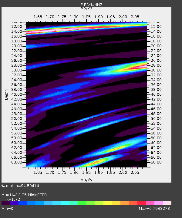
| Estimated Moho Depth: |
13.25 km |
| Estimated Crust Vp/Vs: |
1.72 |
| Assumed Crust Vp: |
6.577 km/s |
| Estimated Crust Vs: |
3.824 km/s |
| Estimated Crust Poisson's Ratio: |
0.24 |
|
| Radial Match: |
94.50416 % |
| Radial Bump: |
265 |
| Transverse Match: |
78.329765 % |
| Transverse Bump: |
400 |
| SOD ConfigId: |
25131211 |
| Insert Time: |
2021-08-12 06:25:15.885 +0000 |
| GWidth: |
2.5 |
| Max Bumps: |
400 |
| Tol: |
0.001 |
|

Signal To Noise
| Channel | StoN | STA | LTA |
| IE:BCYI: :HHZ:20210729T06:21:26.030001Z | 5.170582 | 2.8009053E-6 | 5.417002E-7 |
| IE:BCYI: :HHN:20210729T06:21:26.030001Z | 1.3628602 | 8.8278335E-7 | 6.4774315E-7 |
| IE:BCYI: :HHE:20210729T06:21:26.030001Z | 1.6786277 | 1.5001416E-6 | 8.936714E-7 |
| Arrivals |
| Ps | 1.6 SECOND |
| PpPs | 5.0 SECOND |
| PsPs/PpSs | 6.6 SECOND |


