You are here: Home > Network List > II - Global Seismograph Network (GSN - IRIS/IDA) Stations List
> Station KURK Kurchatov, Kazakhstan > Earthquake Result Viewer
KURK Kurchatov, Kazakhstan - Earthquake Result Viewer
| Earthquake location: |
Alaska Peninsula |
| Earthquake latitude/longitude: |
55.3/-157.8 |
| Earthquake time(UTC): |
2021/07/29 (210) 06:15:45 GMT |
| Earthquake Depth: |
5.2 km |
| Earthquake Magnitude: |
7.3 ml |
| Earthquake Catalog/Contributor: |
NEIC PDE/ak |
|
| Network: |
II Global Seismograph Network (GSN - IRIS/IDA) |
| Station: |
KURK Kurchatov, Kazakhstan |
| Lat/Lon: |
50.72 N/78.62 E |
| Elevation: |
184 m |
|
| Distance: |
64.4 deg |
| Az: |
324.014 deg |
| Baz: |
31.903 deg |
| Ray Param: |
0.058968432 |
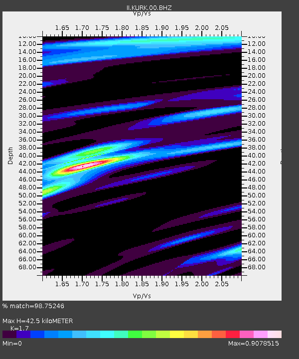
| Estimated Moho Depth: |
42.5 km |
| Estimated Crust Vp/Vs: |
1.70 |
| Assumed Crust Vp: |
6.552 km/s |
| Estimated Crust Vs: |
3.854 km/s |
| Estimated Crust Poisson's Ratio: |
0.24 |
|
| Radial Match: |
98.75246 % |
| Radial Bump: |
271 |
| Transverse Match: |
93.144356 % |
| Transverse Bump: |
396 |
| SOD ConfigId: |
25131211 |
| Insert Time: |
2021-08-12 06:25:23.218 +0000 |
| GWidth: |
2.5 |
| Max Bumps: |
400 |
| Tol: |
0.001 |
|
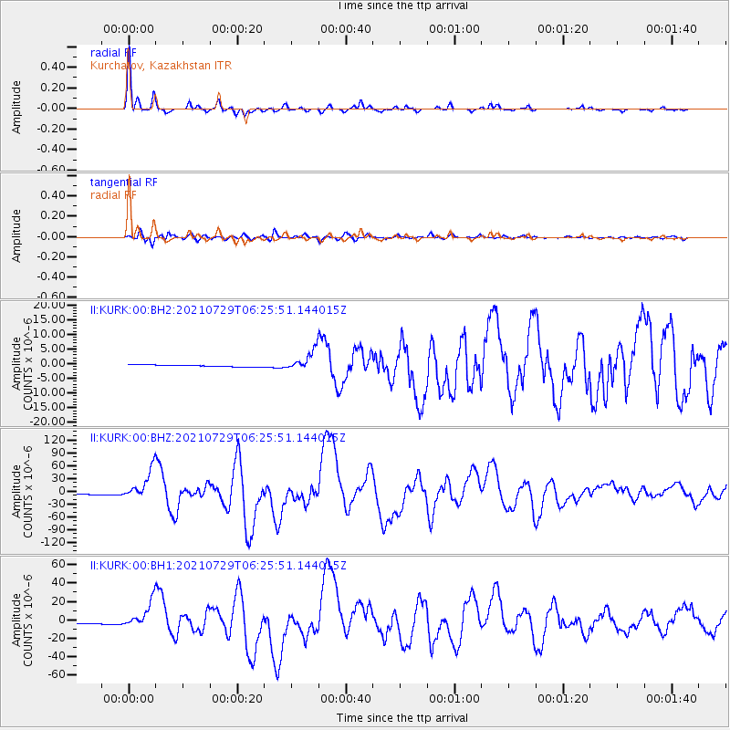
Signal To Noise
| Channel | StoN | STA | LTA |
| II:KURK:00:BHZ:20210729T06:25:51.144015Z | 21.167685 | 3.5132205E-5 | 1.6597094E-6 |
| II:KURK:00:BH1:20210729T06:25:51.144015Z | 15.056876 | 1.4247219E-5 | 9.4622675E-7 |
| II:KURK:00:BH2:20210729T06:25:51.144015Z | 11.058554 | 3.37136E-6 | 3.0486447E-7 |
| Arrivals |
| Ps | 4.8 SECOND |
| PpPs | 17 SECOND |
| PsPs/PpSs | 21 SECOND |


