You are here: Home > Network List > JP - Japan Meteorological Agency Seismic Network Stations List
> Station JHJ2 Hachijojima Island > Earthquake Result Viewer
JHJ2 Hachijojima Island - Earthquake Result Viewer
| Earthquake location: |
Alaska Peninsula |
| Earthquake latitude/longitude: |
55.3/-157.8 |
| Earthquake time(UTC): |
2021/07/29 (210) 06:15:45 GMT |
| Earthquake Depth: |
5.2 km |
| Earthquake Magnitude: |
7.3 ml |
| Earthquake Catalog/Contributor: |
NEIC PDE/ak |
|
| Network: |
JP Japan Meteorological Agency Seismic Network |
| Station: |
JHJ2 Hachijojima Island |
| Lat/Lon: |
33.12 N/139.81 E |
| Elevation: |
70 m |
|
| Distance: |
48.0 deg |
| Az: |
269.339 deg |
| Baz: |
42.94 deg |
| Ray Param: |
0.069645174 |
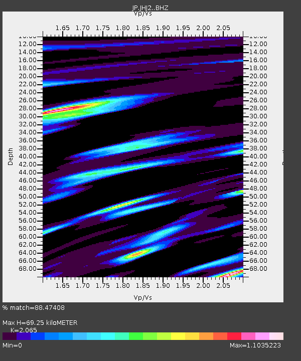
| Estimated Moho Depth: |
69.25 km |
| Estimated Crust Vp/Vs: |
2.07 |
| Assumed Crust Vp: |
4.662 km/s |
| Estimated Crust Vs: |
2.258 km/s |
| Estimated Crust Poisson's Ratio: |
0.35 |
|
| Radial Match: |
88.47408 % |
| Radial Bump: |
400 |
| Transverse Match: |
87.660194 % |
| Transverse Bump: |
400 |
| SOD ConfigId: |
25131211 |
| Insert Time: |
2021-08-12 06:26:28.708 +0000 |
| GWidth: |
2.5 |
| Max Bumps: |
400 |
| Tol: |
0.001 |
|

Signal To Noise
| Channel | StoN | STA | LTA |
| JP:JHJ2: :BHZ:20210729T06:23:54.600008Z | 24.6127 | 3.2226802E-5 | 1.3093567E-6 |
| JP:JHJ2: :BHN:20210729T06:23:54.600008Z | 4.3716464 | 8.56838E-6 | 1.959989E-6 |
| JP:JHJ2: :BHE:20210729T06:23:54.600008Z | 6.4819026 | 1.8000632E-5 | 2.7770598E-6 |
| Arrivals |
| Ps | 16 SECOND |
| PpPs | 44 SECOND |
| PsPs/PpSs | 61 SECOND |


