You are here: Home > Network List > KR - Kyrgyz Digital Network Stations List
> Station KDJ Kadji-Say, Kyrgyzstan > Earthquake Result Viewer
KDJ Kadji-Say, Kyrgyzstan - Earthquake Result Viewer
| Earthquake location: |
Alaska Peninsula |
| Earthquake latitude/longitude: |
55.3/-157.8 |
| Earthquake time(UTC): |
2021/07/29 (210) 06:15:45 GMT |
| Earthquake Depth: |
5.2 km |
| Earthquake Magnitude: |
7.3 ml |
| Earthquake Catalog/Contributor: |
NEIC PDE/ak |
|
| Network: |
KR Kyrgyz Digital Network |
| Station: |
KDJ Kadji-Say, Kyrgyzstan |
| Lat/Lon: |
42.12 N/77.18 E |
| Elevation: |
1830 m |
|
| Distance: |
72.3 deg |
| Az: |
320.219 deg |
| Baz: |
29.455 deg |
| Ray Param: |
0.053776003 |
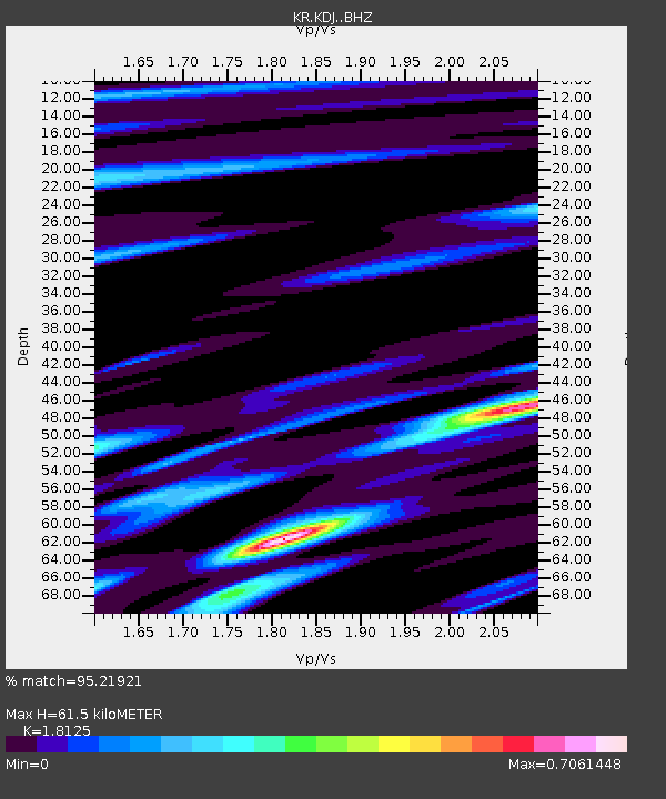
| Estimated Moho Depth: |
61.5 km |
| Estimated Crust Vp/Vs: |
1.81 |
| Assumed Crust Vp: |
6.306 km/s |
| Estimated Crust Vs: |
3.479 km/s |
| Estimated Crust Poisson's Ratio: |
0.28 |
|
| Radial Match: |
95.21921 % |
| Radial Bump: |
400 |
| Transverse Match: |
86.14232 % |
| Transverse Bump: |
400 |
| SOD ConfigId: |
25131211 |
| Insert Time: |
2021-08-12 06:27:08.194 +0000 |
| GWidth: |
2.5 |
| Max Bumps: |
400 |
| Tol: |
0.001 |
|

Signal To Noise
| Channel | StoN | STA | LTA |
| KR:KDJ: :BHZ:20210729T06:26:40.459994Z | 24.637724 | 1.3620759E-5 | 5.528416E-7 |
| KR:KDJ: :BHN:20210729T06:26:40.459994Z | 17.058931 | 4.646373E-6 | 2.7237186E-7 |
| KR:KDJ: :BHE:20210729T06:26:40.459994Z | 13.269893 | 2.1869853E-6 | 1.6480806E-7 |
| Arrivals |
| Ps | 8.2 SECOND |
| PpPs | 27 SECOND |
| PsPs/PpSs | 35 SECOND |


