You are here: Home > Network List > LD - Lamont-Doherty Cooperative Seismographic Network Stations List
> Station UCCT University of Connecticut, Storrs, CT > Earthquake Result Viewer
UCCT University of Connecticut, Storrs, CT - Earthquake Result Viewer
| Earthquake location: |
Alaska Peninsula |
| Earthquake latitude/longitude: |
55.3/-157.8 |
| Earthquake time(UTC): |
2021/07/29 (210) 06:15:45 GMT |
| Earthquake Depth: |
5.2 km |
| Earthquake Magnitude: |
7.3 ml |
| Earthquake Catalog/Contributor: |
NEIC PDE/ak |
|
| Network: |
LD Lamont-Doherty Cooperative Seismographic Network |
| Station: |
UCCT University of Connecticut, Storrs, CT |
| Lat/Lon: |
41.79 N/72.23 W |
| Elevation: |
200 m |
|
| Distance: |
54.7 deg |
| Az: |
65.957 deg |
| Baz: |
315.71 deg |
| Ray Param: |
0.06528005 |
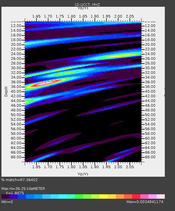
| Estimated Moho Depth: |
36.25 km |
| Estimated Crust Vp/Vs: |
1.69 |
| Assumed Crust Vp: |
6.472 km/s |
| Estimated Crust Vs: |
3.835 km/s |
| Estimated Crust Poisson's Ratio: |
0.23 |
|
| Radial Match: |
97.36402 % |
| Radial Bump: |
232 |
| Transverse Match: |
97.38503 % |
| Transverse Bump: |
237 |
| SOD ConfigId: |
25131211 |
| Insert Time: |
2021-08-12 06:27:51.196 +0000 |
| GWidth: |
2.5 |
| Max Bumps: |
400 |
| Tol: |
0.001 |
|

Signal To Noise
| Channel | StoN | STA | LTA |
| LD:UCCT: :HHZ:20210729T06:24:44.660006Z | 5.3612 | 1.9374477E-6 | 3.6138326E-7 |
| LD:UCCT: :HHN:20210729T06:24:44.660006Z | 1.0059243 | 6.751096E-10 | 6.711335E-10 |
| LD:UCCT: :HHE:20210729T06:24:44.660006Z | 3.851053 | 8.096961E-9 | 2.1025317E-9 |
| Arrivals |
| Ps | 4.1 SECOND |
| PpPs | 14 SECOND |
| PsPs/PpSs | 18 SECOND |


